Rocks Reveal an Extraordinary Mountain Building Process
Granite now exposed in Japan's Northern Alps formed about 800,000 years ago at depths of 6 to 9 kilometres. Its journey to the surface records an extraordinary combination of rising rock and erosion, with estimated rates of exposure reaching 7.5 to 10.2 millimetres a year, among the fastest documented for mountain building over geological timescales.
Contents
- Rocks Reveal an Extraordinary Mountain Building Process
- Why the Northern Alps Were a Puzzle
- How Researchers Read the Granite's History
- What One Centimetre a Year Means
- How Magma Heat Helps the Crust Deform
- A Different Setting From Continental Collision
- The Study's Geological and Publication Timeline
- Why the Findings Matter for Japan
- Key Points
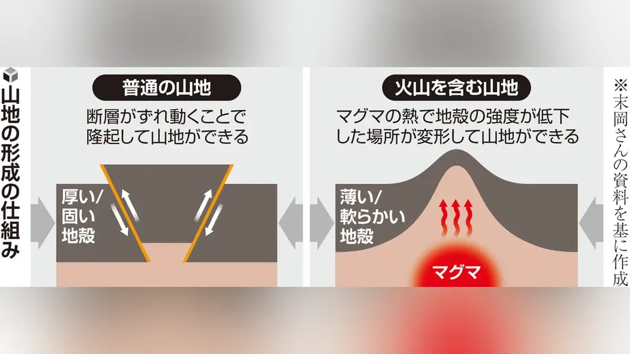
A study led by Shigeru Sueoka, a researcher at the Japan Atomic Energy Agency's Tono Geoscience Center, offers an explanation: heat from underground magma weakened the Earth's crust, allowing horizontal pressure to squeeze particular areas upward especially quickly.
The Japan Atomic Energy Agency, Kyoto University and Nihon University announced the findings on August 19, 2026. The agency's research announcement describes evidence from the Kurobe region, where some of the world's youngest known granite lies exposed at the surface.
The findings connect two parts of the landscape's history. Rock measurements reveal how quickly deeply buried granite became exposed. Computer simulations suggest why deformation concentrated in this particular part of central Japan: volcanic heat made the crust easier to deform under compression.
Why the Northern Alps Were a Puzzle
Japan's Central and Southern Alps have large, clearly identified faults associated with their formation. A fault is a break in rock along which the two sides move. Repeated movement can gradually lift one side and help create a mountain range.
The Northern Alps, also called the Hida Mountains, presented a different problem. Scientists had not identified a fault around the range that adequately explained its uplift. Volcanoes within the mountains suggested that magma might play a part, but the physical connection needed investigation.
The nearby Itoigawa-Shizuoka Tectonic Line added a useful detail. According to the agency's explanation, its movement raises the ground on its eastern side, opposite the Northern Alps. Researchers therefore needed to explain how the mountains themselves had risen so rapidly.
Kurobe's unusually young granite offered a way to investigate. Granite forms when magma cools and solidifies deep underground. Finding young granite at the surface means that the rock above it has been removed within a comparatively short span of geological time.
How Researchers Read the Granite's History
The team collected granite at 12 locations, at elevations of approximately 700 to 2,400 metres. The study area covered Kurobe City and Tateyama Town in Toyama Prefecture, and Omachi City and Hakuba Village in Nagano Prefecture. Samples included the Kurobegawa Granite, identified by the institutions as the world's youngest known exposed granite.
Researchers needed two measurements: when the granite formed and how deeply it was buried at that time. Together, those measurements allow scientists to estimate how quickly the rock became exposed.
For the age, they used zircon uranium-lead dating. Zircon is a mineral that can contain small amounts of uranium. Uranium gradually changes into lead at a known rate, giving scientists a natural clock inside the rock. Measuring the uranium and lead helps establish when the zircon formed.
For the original depth, the team used geothermobarometry. This method examines mineral combinations and chemical compositions to estimate the temperature and pressure when a rock formed. Pressure provides a guide to how much rock lay above it, allowing scientists to estimate its burial depth.
Kyoto University researchers performed the mineral chemistry analyses using an electron probe microanalyser. Uranium-lead measurements used equipment at the Tono Geoscience Center that removes tiny amounts of material with a laser and measures their chemical contents. The two methods supplied different pieces of the same geological history.
What One Centimetre a Year Means
The analyses placed the granite's formation about 800,000 years ago, at depths of 6 to 9 kilometres. The agency explains that the overlying rock was subsequently removed by erosion, leaving granite that had formed deep underground visible today.
The study estimates exposure rates of approximately 7.5 to 10.2 millimetres annually. The institutions describe this more simply as roughly 1 centimetre a year. In geological terms, that is exceptionally fast when maintained across hundreds of thousands of years.
A simple calculation helps show the scale. Removing 6 kilometres of rock over 800,000 years gives an average of 7.5 millimetres a year. The study's detailed range comes from its rock analyses, while this calculation illustrates how an annual change smaller than a finger's width can expose material once buried kilometres below the surface.
Geologists call the process of deeply buried rock approaching and reaching the surface exhumation. Uplift moves rock upward; erosion removes material above it. Both processes shape the landscape, and their balance determines how mountain elevations change while deeper rocks become exposed.
The agency places Kurobe among the fastest examples worldwide, alongside mountain regions in the Himalayas, the European Alps, Taiwan and New Zealand. The comparison concerns the speed at which buried rock becomes exposed over geological time, with Kurobe reaching rates usually associated with some of the world's most active mountain building regions.
How Magma Heat Helps the Crust Deform
The team next investigated why deformation could be so concentrated in Kurobe. Its proposed mechanism brings together underground heat and horizontal compression: magma heats the crust, warmer rock loses strength, and pressure squeezes the weakened area more readily.
Researchers built a three dimensional computer model using observations of underground temperatures to estimate crustal strength across central Japan. They then simulated what would happen when horizontal forces compressed that crust.
The simulations produced particularly rapid, localised uplift in areas affected by volcanic heat, including the Northern Alps. Those results matched the broad pattern suggested by the granite: unusually strong deformation concentrated within a limited region.
The explanation is similar to squeezing material that contains a softer section. Under the same applied force, that section changes shape more easily than its stronger surroundings. In the mountains, the softer zone is crust heated by magmatic activity, and deformation can include upward movement.
The study links the heat pattern along the volcanic arc with horizontal shortening during the later part of the Quaternary, the geological period that includes the present. Shortening means that a section of crust occupies less horizontal distance as it is compressed, with rock deforming and thickening in response.
The amount of rapid exposure is supported by the rock measurements; the heat driven mechanism is the explanation supported by the simulations. Researchers still need to test how widely the same combination operates in other mountain regions.
A Different Setting From Continental Collision
The Himalayas and European Alps are familiar examples of mountains formed through continental collision. When continental plates push together, their crust can fold, break and thicken, producing high mountains and exposing deeply buried rocks.
Japan occupies a subduction setting, where an oceanic plate descends beneath another plate. These regions often contain chains of volcanoes known as volcanic arcs. The study shows how the thermal structure associated with such an arc can help concentrate mountain building.
Kurobe therefore provides a link between processes often examined separately: volcanic activity below the ground and the movement and erosion of mountains above it. Magma supplies heat, compression supplies force, and erosion removes rock as the landscape evolves.
The paper also discusses possible contributions from fluids released by the descending plate. Its central result is that the underground conditions associated with subduction can help produce exceptionally rapid exposure of deep crustal rocks, complementing fault movement and folding.
The Study's Geological and Publication Timeline
The research combines a history stretching back hundreds of thousands of years with laboratory measurements and modern computer modelling. Its key dates are:
- About 800,000 years ago: the studied granite formed roughly 6 to 9 kilometres underground.
- Over approximately the following 800,000 years: rapid uplift and erosion brought the granite to the surface in the Kurobe region.
- August 3, 2026: the paper appeared online in Earth and Planetary Science Letters, according to the institutions.
- August 19, 2026: the Japan Atomic Energy Agency, Kyoto University and Nihon University announced the findings.
Kyoto University's publication record identifies the paper as Extreme exhumation along a volcanic arc exposed the world's youngest pluton in the Japanese Alps, published in volume 692 of Earth and Planetary Science Letters as article 120218. A pluton is a body of rock formed when magma solidifies underground.
Sueoka worked with researchers including Kyoto University professor Tetsuo Kawakami, assistant professor Fumiko Higashino and emeritus professor Takahiro Tagami, agency researchers Saya Kagami and Takanori Yokoyama, and Nihon University researcher Mitsuhiro Nagata. Bunichiro Shibazaki of the Building Research Institute carried out the crustal deformation modelling.
Why the Findings Matter for Japan
The researchers plan to investigate whether similar processes operate elsewhere in Japan and around the Pacific. Comparing volcanic mountain regions would help establish where underground heat concentrates deformation and where other mechanisms play larger roles.
Earthquake activity is another research direction. Sueoka has pointed to the possibility of helping explain earthquakes associated with faults that were not clearly identified beforehand, such as the 2008 Iwate-Miyagi inland earthquake. The proposed connection concerns how heated crust deforms and where that deformation concentrates.
The institutions also identify future work on the distribution, frequency and mechanisms of earthquakes in subduction regions. For Japan, the practical scientific task is to understand how volcanic heat, compression and rock strength combine beneath landscapes where mountains and earthquakes develop together.
The analytical approach may also help researchers estimate erosion in volcanic regions where conventional methods face difficulties. Reconstructing how quickly deep rocks have reached the surface gives scientists a firmer basis for studying continuing crustal movement and future changes in terrain.
The project received support from Japan's Agency for Natural Resources and Energy through research on assessing the long term stability of geological environments for radioactive waste disposal, and from Japan Society for the Promotion of Science funding on deformation of the Japanese islands. Both research areas depend on understanding how rock and landscapes change across very long periods.
Key Points
- Granite exposed in Kurobe formed about 800,000 years ago at depths of 6 to 9 kilometres.
- Estimated exposure rates of 7.5 to 10.2 millimetres a year place the region among the world's fastest examples over geological timescales.
- Computer models suggest that magma heat weakened the crust, concentrating deformation under horizontal compression.
- The findings explain how a volcanic arc can experience rapid mountain building alongside uplift and erosion.
- Further research will compare other subduction regions and examine connections with earthquake activity.