Fire crews confront a growing national emergency
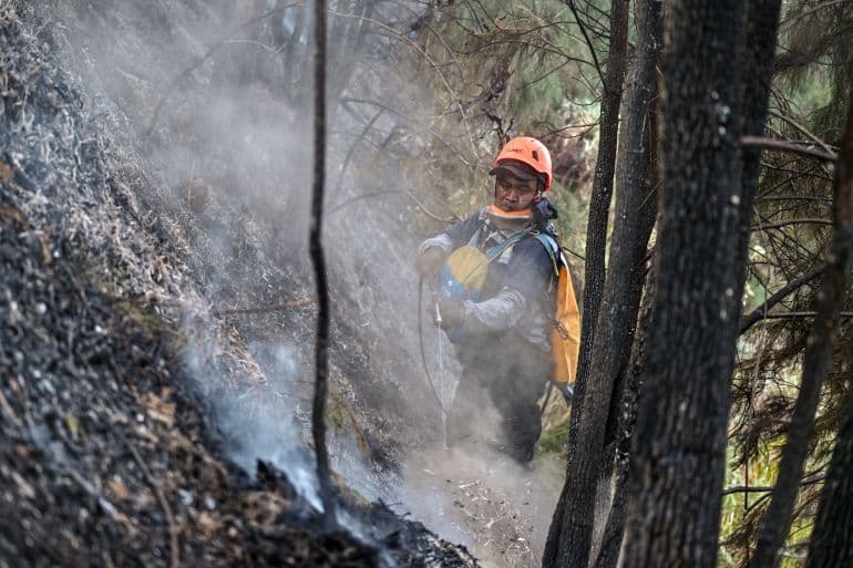
Nearly 50,000 firefighters and disaster personnel, supported by dozens of helicopters, are battling wildfires across Indonesia as a severe dry season raises the risk of a wider crisis. More than 107,000 hectares of forest and land burned nationwide between January and June, according to Indonesia’s forestry ministry. That figure is twice the area burned during all of 2023.
- Fire crews confront a growing national emergency
- Why peat fires are so difficult to stop
- How El Nino is changing the weather
- Cloud seeding is unavailable as fires spread
- Drought threatens farms, water supplies and the economy
- Smoke crosses borders and threatens public health
- Land management remains central to the crisis
- What to Know
The most visible blaze is burning in East Java’s Bromo Tengger Semeru National Park, where about 743 hectares have been scorched. The fire has consumed dry grassland, vegetation and protected Edelweiss flowers, with flames spreading toward Penanjakan, a well known viewpoint overlooking Mount Bromo.
Park authorities have closed the site to visitors until further notice. No injuries or building evacuations have been reported, although officials say the closure is needed to protect tourists, staff and nearby communities.
Djamari Chaniago, Indonesia’s Coordinating Minister for Political and Security Affairs, said stronger El Nino conditions had raised the danger of forest and land fires during the peak dry season. August and September are expected to bring the most dangerous fire conditions, as vegetation dries further and winds help flames spread.
Why peat fires are so difficult to stop
Firefighters are also working across Sumatra and Borneo, where large areas of peatland are burning. Authorities have reported fires in Riau, Jambi and South Sumatra, as well as Central Kalimantan and South Kalimantan. In Jambi, thousands of personnel have been deployed, supported by three firefighting helicopters.
Peat is partially decayed plant material that has accumulated in waterlogged soil over centuries. It can store far more carbon than ordinary mineral soil. When peatlands are drained for plantations or agriculture, the soil becomes highly flammable. Fire can move below the surface and continue burning for weeks or months, making it difficult to detect and extinguish.
Deep peat, limited water supplies, strong winds and difficult access are complicating operations in Jambi. A fire may appear to be under control at the surface while continuing underground, where water from ordinary firefighting may not reach the burning material.
Environmental groups have warned that land conversion is increasing the danger. Central Kalimantan contains peat landscapes targeted for food production, including rice cultivation. Janang Palanungkai of Walhi, Indonesia’s largest environmental organization, said farming on drained peatlands could repeat mistakes made during earlier development projects.
What we are most concerned about is the rice paddy cultivation activity that is being carried out on peatlands, Janang Palanungkai said.
The concern recalls the former Mega Rice Project in Central Kalimantan. Large canals drained peat domes in the 1990s, leaving the land much more vulnerable during the powerful 1997 to 1998 El Nino. Environmental groups say weak oversight of plantation concessions and land clearing continues to add to the risk.
How El Nino is changing the weather
El Nino begins when surface waters in the equatorial Pacific become unusually warm for several months. The warming disrupts air pressure, winds and rainfall patterns around the world. Indonesia and much of Southeast Asia commonly experience less rain and higher temperatures during the event.
Indonesia’s Meteorology, Climatology and Geophysics Agency, known as BMKG, has warned that the 2026 dry season will be longer and more intense than usual. Rainfall in some areas could fall below 20 millimeters per month, with southern regions including Java, Bali, Nusa Tenggara, southern Sumatra and southern Papua facing particular pressure.
Forecasts differ on how strong the event will become. Some projections point to a moderate or strong El Nino, while United States forecasters have assigned a possibility that it could reach very strong intensity. The informal phrase Godzilla El Nino is sometimes used for an exceptionally powerful event, although it is not a scientific classification.
El Nino also combines with other climate patterns. A positive Indian Ocean Dipole can further reduce rainfall over Indonesia. When both patterns occur together, historical fire seasons have often been more severe.
The World Meteorological Organization has warned that the 2026 El Nino will affect weather far beyond Indonesia. The agency expects higher temperatures across many land areas, with increased risks of heatwaves, drought and flooding. WMO Secretary General Celeste Saulo said forecasts must be followed by action that protects exposed communities.
Forecasts in themselves do not prevent hazards; people do, Celeste Saulo said.
Cloud seeding is unavailable as fires spread
Authorities had considered weather modification, commonly called cloud seeding, as a way to generate rain over fire affected areas. The method involves releasing particles such as salt into suitable clouds, allowing water droplets or ice crystals to form and fall as rain.
Current conditions have made that option unavailable. Scientific monitoring found no rain bearing clouds suitable for cloud seeding through the most critical period. Forestry Minister Raja Juli Antoni said crews were therefore relying on water bombing from aircraft and teams working on the ground.
Cloud seeding cannot create rain from clear skies. It requires clouds with enough moisture and the right atmospheric structure. During a strong dry season, the absence of suitable clouds can leave firefighters with few options beyond digging containment lines, pumping water and attacking flames from the air.
Authorities are asking residents to avoid actions that could start new fires. Discarded cigarette butts, unattended cooking fires and land clearing by burning can quickly ignite dry grass or damaged peat. Officials are also focusing patrols, hotspot monitoring and early warnings in provinces near Malaysia and other neighboring areas.
Drought threatens farms, water supplies and the economy
The fire emergency is part of a wider drought crisis. Indonesia’s Ministry of Public Works has responded to drought in 492 locations. Work at 442 sites has been completed, while 50 sites remain active.
The response has protected 22,210 hectares of rice fields and supplied clean water to 155,228 people. Java accounts for most of the activity, with support reaching 305 locations, 12,875 hectares of farmland and more than 125,000 residents.
Other measures include emergency water distribution, improved irrigation management, boreholes, water storage maintenance and drought resistant crop varieties. The government is also considering agricultural insurance and rice reserves to reduce the effects of crop losses.
Finance Minister Purbaya Yudhi Sadewa said President Prabowo Subianto had ordered preparations for an economic stimulus package for the second half of 2026. The details are still being discussed with other ministries. Government planners estimate that losses across key sectors could exceed 2 quadrillion rupiah, or about $111 billion, without early action.
El Nino can reduce rice, palm oil and coffee production while increasing demand for electricity as households use more fans and air conditioning. Lower reservoir levels can also reduce irrigation and hydropower generation. Fisheries and aquaculture may face pressure from warmer water and changing rainfall patterns.
Smoke crosses borders and threatens public health
Indonesia’s fires frequently create a regional haze problem. Smoke from Sumatra and Borneo can travel across the Malacca Strait and reach Malaysia and Singapore when seasonal winds shift.
Malaysia has already recorded unhealthy air quality in several parts of Sarawak and Selangor. Serian recorded an Air Pollutant Index reading of 185, while Kuching reached 165. Experts said winds during the southwest monsoon were carrying smoke from fires in Kalimantan toward Sarawak.
Haze contains fine particles known as PM2.5, which can enter deep into the lungs and worsen asthma, heart disease and other respiratory conditions. Children, older people, pregnant women and outdoor workers face higher risks. In Pekanbaru, haze has reduced visibility at the main airport, while residents in other Riau communities have reported persistent smoke.
Dry weather can also increase risks from dengue, malaria and illnesses linked to unsafe water. Health authorities are preparing disease monitoring, public warnings and clean water supplies as temperatures rise and sanitation becomes more difficult.
Past fire seasons show the possible scale of the danger. The 2015 fires produced widespread haze across Indonesia, Malaysia and Singapore, causing hundreds of thousands of respiratory infections. Fires during the 1997 to 1998 El Nino also created lasting damage to forests, peatlands and public health.
Land management remains central to the crisis
Weather is increasing the fire risk, yet many fires begin through human activity. Small farmers may use fire to clear land, while plantation operations and illegal land clearing can create much larger burns. Environmental groups say enforcement has often been uneven, with local communities facing stronger action than companies whose concessions experience repeated fires.
Satellite monitoring has found many hotspots inside oil palm and timber concessions. This has prompted calls for stronger supervision, restored water levels in peatlands and tougher action against those responsible for negligent or deliberate burning.
Indonesia’s response plan covers four broad areas: agriculture and forestry, energy and water, healthcare, and fisheries and food. Officials are combining fire patrols with irrigation repairs, peatland restoration, emergency water supplies and planning for climate sensitive diseases.
The immediate task is to prevent current fires from spreading through the driest months. The longer task is to reduce the vulnerability created by drained peat, poorly managed concessions and development in fire prone landscapes. Without those changes, each severe El Nino can turn a seasonal dry period into a national emergency.
What to Know
- More than 107,000 hectares burned across Indonesia between January and June 2026.
- About 743 hectares have burned in Bromo Tengger Semeru National Park.
- Nearly 50,000 firefighters and disaster personnel are involved in the response.
- Cloud seeding is unavailable because suitable rain bearing clouds are absent.
- Drought response has reached 492 locations and supplied clean water to 155,228 people.
- Smoke has caused unhealthy air readings in parts of Malaysia.
- August and September are expected to be the most dangerous months for fires.