
Less mud, but a river still raised above the land
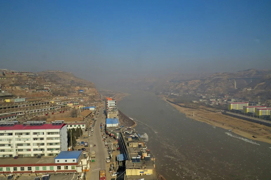
At Tongguan in Shaanxi province, where the Yellow River leaves the Loess Plateau, instruments show sediment concentrations falling from 25.9 kilograms per cubic metre a decade ago to 5.11 kilograms, a drop of about 80%. Yet researchers examining the river's future say the danger facing communities downstream remains substantial.
Contents
- Less mud, but a river still raised above the land
- What the falling sediment figures actually measure
- How erosion control changed the river
- Reservoir releases have opened the channel
- Why people on the floodplain remain exposed
- The biggest disagreement is about future sediment
- Why the delta still needs mud
- A wider river with three floodplain zones
- Can sediment become a resource?
- What to Know
Wang Hao, an academician of the Chinese Academy of Engineering and a researcher at the China Institute of Water Resources and Hydropower Research, put the lower river's floodplain population at about 1.636 million. Of those, roughly 557,000 could face flooding deeper than half a metre during a flood with a 5% chance of occurring in any year.
The river's central problem is its raised bed. Generations of sediment deposits have lifted parts of the lower Yellow River above the surrounding countryside, leaving embankments to contain water flowing at an elevated level. Removing incoming mud helps, but managing the sediment already stored in the river and reservoirs remains a much larger task.
At the 805th Xiangshan Science Conference, researchers debated how much sediment will arrive in future, how scarce water should be used to move it, and where that sediment should ultimately go. Their proposals ranged from reshaping floodplains to processing coarse sand and using dredged material to restore mining land.
The stakes extend beyond flood protection. Sediment that causes trouble upstream also supplies the Yellow River delta with material needed to maintain its coastline and wetlands. River managers therefore face competing needs: keeping channels open, preserving reservoir capacity, protecting settlements and delivering enough water and sediment to the sea.
What the falling sediment figures actually measure
Wang Hao said average annual sediment arriving at Tongguan had fallen from a historical benchmark of 1.6 billion tonnes to about 170 million tonnes over the past decade, a reduction of nearly 90%. A broader basin review published on November 9, 2026, put the average amount entering the Yellow River at 270 million tonnes a year. The figures cover different measures and averaging periods: sediment reaching one station and sediment entering the river across the basin.
Sediment concentration and annual sediment load also describe different things. Concentration measures how much mud is carried in a given volume of water. Annual load measures the total mass passing a location over a year, which also depends on how much water flows through it.
An official academic water and sediment dataset, credited to Zhang Yaonan, Kang Jianfang and Liu Chun and updated on May 29, 2025, records both annual sediment loads and annual average concentrations at 12 stations. They include Tongguan, Sanmenxia, Xiaolangdi, Huayuankou, Gaocun and Lijin, allowing changes to be examined along the river rather than at a single point.
The catalogue title identifies 2015–2018, while its description says the records cover 2015–2019. Its stated indicators make the practical task clear: tracking both waterborne sediment concentration and total sediment movement is necessary to understand what reaches reservoirs, floodplains and the coast.
How erosion control changed the river
The Loess Plateau supplies much of the Yellow River's sediment. Its loose soils can be carried into gullies during heavy rain, then travel through tributaries into the main river. Trees, grass, terraces and small dams interrupt that journey.
By 2024, the basin had 541,300 square kilometres of forest and grass vegetation, 62,400 square kilometres of terraces and 58,300 sediment trapping dams. The area affected by soil erosion had fallen from 454,000 square kilometres in 1990 to 245,800 square kilometres, a reduction of about 46%.
More recent figures from the Yellow River Basin Soil and Water Conservation Bulletin (2025), issued by the Ministry of Water Resources' Yellow River Conservancy Commission and reported on May 8, 2026, put the dam total at 60,200 and the soil and water conservation rate at 69.75% as of 2025. The dams have created about 85,300 hectares of productive land as trapped sediment accumulated behind them. Together, dams and the conversion of slopes into terraces have intercepted roughly 10 billion tonnes or more of sediment.
Local results show the scale of that work. By July 2026, Yan'an's sediment trapping dams had retained a cumulative 1 billion tonnes, and its average annual sediment contribution to the Yellow River had fallen by more than 80%. Ordos reported a reduction of nearly 85%, alongside treatment of 50% of the Kubuqi Desert and 85% of the Mu Us sandy land.
Reservoir releases have opened the channel
Xiaolangdi Reservoir began coordinated water and sediment regulation in 2002. Operators release water in carefully managed pulses to scour deposited material from reservoirs and channels and carry it downstream. Reservoirs elsewhere in the system help control the timing and strength of these flows.
A regulation operation lasting 19 days and ending on July 10, 2026, discharged 179 million tonnes of sediment from Xiaolangdi and removed a net 171 million tonnes from its reservoir area. Both were described as records for comparable seasonal operations.
Wang Hao said coordinated reservoir operations had helped raise the minimum flow the lower river's main channel can carry before spilling onto its floodplain from 2,400 to about 4,700 cubic metres per second. That is almost twice the earlier capacity. The wider protection system now includes 40 major hydraulic projects on the main river and tributaries, plus 1,371 kilometres of standardised embankments downstream.
The principal milestones span several decades:
- 1987: A Yellow River water allocation scheme established a framework for sharing the river's water.
- 1999: The Ministry of Water Resources began unified water allocation and scheduling across the river.
- 2002: Xiaolangdi began its first water and sediment regulation operation.
- July 10, 2026: The latest cited summer operation ended after 19 days.
- 2030: Basin managers aim to raise the soil and water conservation rate above 70%.
Why people on the floodplain remain exposed
Zhang Min, a senior engineer at the Yellow River Institute of Hydraulic Research, said more than two decades of managed releases had scoured about 2.4 billion cubic metres from the lower channel. One measure of the height difference between the floodplain and channel fell from a maximum of 1.9 metres to 0.4 metres.
Another critical feature has changed much less: the difference in elevation between the raised edge of the floodplain near the channel and the ground at the embankment's foot remains about three metres on average. Floodwater spilling out of the channel can therefore still threaten people living within the embanked corridor.
The lower floodplain covers approximately 3,154 square kilometres. Wang Hao's estimate of 557,000 people exposed to water deeper than half a metre in a flood with a 5% annual probability amounts to about one third of its population. Relocation requires substantial spending and asks families to leave established homes and livelihoods.
Wang Hao said the existing engineering system could, under ideal conditions, defend against a flow of 22,000 cubic metres per second at Huayuankou near Zhengzhou, roughly the estimated flood with a 1% annual probability. He also warned that an extreme flood with a 0.1% annual probability, combined with embankment failure, could threaten more than 100 million people across Henan, Shandong, Hebei, Anhui and Jiangsu. These probabilities describe annual chances, rather than a timetable between floods.
The biggest disagreement is about future sediment
Researchers at the conference offered sharply different expectations for Tongguan. Some considered a future annual sediment load of around 800 million tonnes possible, arguing that climate changes and the durability of erosion control measures create uncertainty.
Others expected the long term annual average to stay below 300 million tonnes, rising to around 500 million tonnes even during an extreme rainstorm comparable to the one in 1933. Wang Hao supported the lower estimates. He argued that erosion through sediment trapped behind dams would tend to cut narrow channels rather than release all the accumulated material together.
Li Zhanbin, a professor at Xi'an University of Technology, pointed to a more concentrated problem. Areas generating abundant coarse sediment occupy about 10% of the basin but contribute roughly 60% of its sediment. He said recent sediment reductions in those difficult areas had been only about 2%.
Coarse particles settle more readily than fine particles, making them especially troublesome for reservoirs and raised riverbeds. Even an annual load of 200 million tonnes would leave a deposition problem if a substantial part consisted of coarse material.
Water availability adds another uncertainty. Wang Hao cited a decline in the basin's water resources from a benchmark of 58 billion cubic metres to 49.3 billion cubic metres in 2016. Wang Guoqing, a senior engineer at the Nanjing Hydraulic Research Institute, expected natural runoff to decline further. Less water means less carrying capacity, even when the total sediment supply is lower.
Why the delta still needs mud
The Yellow River delta depends on sediment to replace material removed by waves, tides and coastal erosion. Researchers at the conference put the approximate sediment supply needed to maintain its dynamic balance at 260 million tonnes a year. Since 2000, measured annual loads at Lijin, near the river's mouth, have been below 100 million tonnes in nearly half of all years, less than 40% of that estimated requirement.
Freshwater restoration has nevertheless produced visible ecological gains. Recent years have brought a cumulative 1.82 billion cubic metres of ecological water replenishment to the delta, including renewed flow to the former Diaokou channel after 34 years without river flow.
Within a specified period of five years, restoration work connected 241 kilometres of waterways, supplied 860 million cubic metres of ecological water and restored about 3,467 hectares of salt tolerant seepweed. A separate 2025–2026 accounting recorded 216 million cubic metres supplied to the delta. The different totals cover different periods.
The nature reserve now records 407 bird species, compared with 187 when it was established. Maintaining those habitats requires freshwater and sediment management together: water supports wetland conditions, while sediment helps sustain the land beneath them.
A wider river with three floodplain zones
Wang Hao favoured retaining a broad river corridor and strong embankments, even with lower future sediment loads. His proposal divides the space outward from the main channel into three functional zones rather than narrowing the river simply because it currently carries less mud.
The lowest zone would carry floods and sediment. A middle zone would temporarily store floodwater and allow sediment to settle. A higher zone would provide safer platforms for settlements. Floodwater would have space to spread, while sediment would have designated places to accumulate.
Wang Hao argued that the densely populated and economically developed areas beside the lower river make embankment protection a lasting priority. A broad corridor supplies storage space during exceptional floods, particularly as extreme rainfall tests flood defences.
At the coast, he proposed coordinating water and sediment releases with ecological water replenishment, restoring aquaculture areas to tidal flats, coastal protection and artificial sediment placement. The conference proposals have no stated implementation timetable.
Can sediment become a resource?
Wang Fei, a professor at Northwest A&F University and deputy director of the Institute of Soil and Water Conservation under the Chinese Academy of Sciences and the Ministry of Water Resources, proposed separating coarse and fine particles and reducing the size of coarse sediment. The aim is to make sediment easier for the available water to carry.
He estimated that such techniques could increase carrying capacity by four to ten times and potentially save 5 billion to 10 billion cubic metres of water annually. His proposal also envisaged delivering 50 million to 100 million tonnes of sediment to the estuary each year, contributing to the delta's needs.
Sanmenxia and Xiaolangdi together contain about 4 billion cubic metres of coarse sediment, Wang Fei said. Treating one quarter of that volume could recover 1 billion cubic metres of reservoir storage. These figures describe the proposal's potential benefits, with practical performance dependent on implementation.
Hu Zhenqi, an academician of the Chinese Academy of Engineering and professor at China University of Mining and Technology, described another use: restoring land damaged by mining. A demonstration project in Shandong achieved full land reclamation within its project area, with maize yields of 10,484.54 kilograms per hectare, comparable to ordinary farmland.
Other proposals included using sediment in mortar, repair materials and ecological slope protection bricks. Such uses could create destinations for dredged material while helping pay for its removal, although the conference gave no figures for costs or the quantities that markets could absorb.
What to Know
- Sediment concentration at Tongguan has fallen about 80% over a decade, but the lower river's elevated bed and floodplain exposure remain major concerns.
- About 557,000 floodplain residents could face water deeper than half a metre during a flood with a 5% annual probability.
- Reservoir operations have almost doubled the lower main channel's minimum capacity before water spills onto the floodplain.
- Researchers disagree on future sediment loads, while coarse sediment and declining water availability complicate management.
- The delta needs sediment to sustain its coastline, alongside freshwater to support wetland habitats.
- Proposals include three floodplain zones, sediment processing and reuse, with a conservation target above 70% by 2030.