A shrinking ice reserve above Bhutan's valleys
Bhutan has lost 27 glaciers since its previous national inventory, while its glacier area has fallen by more than 57 square kilometres, according to the National Centre for Hydrology and Meteorology (NCHM). The Bhutan Glacier Inventory 2026 counts 673 glaciers covering nearly 572 square kilometres, a reduction in area of more than 9 percent from the 2018 inventory.
Contents
- A shrinking ice reserve above Bhutan's valleys
- What the new inventory measures
- Mountain stations record rising temperatures
- Three glaciers reveal losses beneath the surface
- Why melting ice matters downstream
- Growing lakes create another danger
- What the changes mean for Laya
- The record so far and the next scientific step
- Key Points
Far above the valleys, those changes surround places such as Wakila in Laya, where Dorji herds yaks across alpine pastures more than 5,000 metres above sea level. His work continues a livelihood passed through generations. Shrinking ice and changing mountain conditions threaten the water supplies, pastures and highland environment on which communities like his depend.
The consequences extend downstream. Glaciers help supply Bhutan's rivers, which support drinking water, irrigation and hydropower generation. Retreating ice also contributes to the growth of glacial lakes, increasing the danger of floods when a lake suddenly releases its water.
The inventory brings together satellite images collected between 2016 and 2025. Alongside measurements from individual glaciers and temperature records from high mountain stations, it shows how Bhutan's frozen water reserves are changing, and why planning for water shortages and sudden floods must happen together.
What the new inventory measures
NCHM used satellite imagery, machine learning and deep learning to prepare the inventory. These computer methods help identify glacier boundaries across large, difficult mountain areas. The centre says the approach improves mapping accuracy and consistency while reducing human error.
The loss of more than 57 square kilometres describes the reduction in the surface area covered by glaciers. Measurements of ice thickness and mass provide another part of the picture: a glacier can become thinner while still covering some of the same ground.
The Pho Chhu sub-basin remains Bhutan's largest concentration of glaciers, with 200 covering more than 230 square kilometres. That is about 30 percent of the country's 673 glaciers and roughly two fifths of its nearly 572 square kilometres of glacier area. Changes within this basin therefore account for a substantial part of Bhutan's exposure to melting ice.
An earlier account associated with the Bhutan Glacial Lake Inventory 2021 listed 567 glaciers covering 55.04 square kilometres. The relationship between those figures and the 2026 glacier inventory has not been explained. The latest national assessment gives the current headline totals of 673 glaciers and nearly 572 square kilometres.
Mountain stations record rising temperatures
Zanam in Gasa, at about 4,900 metres above sea level, warmed by 0.79 degrees Celsius between 2000 and 2025. Lunana recorded an increase of 0.83 degrees over the same period, according to temperature records cited by NCHM.
Those increases matter because a glacier survives through a balance between gains and losses. Snowfall adds material that can become ice, while melting removes it. When losses repeatedly exceed the amount added, the glacier becomes thinner, smaller or both.
Karma, a specialist at NCHM, linked Bhutan's retreating glaciers to rapid warming at high elevations, where the country's glaciers are located. The temperature measurements give a local explanation for changes visible in the satellite inventory.
Across Asia, the mean temperature in 2023 was 0.91 degrees Celsius above the average for 1991 to 2020, making it the region's second warmest year on record, according to the State of the Climate in Asia 2023 assessment. Bhutan's mountain observations place its glacier losses within that broader regional warming.
Three glaciers reveal losses beneath the surface
Measurements presented by Sonam Lhamo, principal hydrology and meteorology officer at NCHM, show the changes at three benchmark glaciers: Gangjula, Thana and Shodug. Benchmark glaciers are monitored repeatedly so scientists can track changes over time.
Gangjula, which supplies the headwaters of the Pho Chhu and Punatsangchhu river systems, lost 30 percent of its ice between 2004 and 2020. Its recorded thickness was 96.4 metres in 2019. The presentation put its annual water loss at 369 million litres and indicated that the glacier is expected to disappear within this century.
Thana, at the headwaters of the Chamkharchhu and Manas basin, had a reported thickness of 210 metres. The figures presented by Lhamo put its annual loss at 6 billion litres of water, equivalent to 7 percent of its glacial ice.
Shodug, which supplies the headwaters of the Thimchhu, had a recorded thickness of 126.6 metres in 2021. Its mass balance for 2021 to 2022 was minus 1,762.29 millimetres of water equivalent per year. In simple terms, the glacier lost an amount of ice equivalent to a layer of water about 1.76 metres deep spread across its surface.
These measurements describe different aspects of glacier change: ice volume, water loss and the balance between accumulation and melting. Together with the national mapping, they show why counting glaciers alone gives only part of the picture.
Why melting ice matters downstream
Bhutan's glaciers store water high in the mountains and release some of it as they melt. Their contribution forms part of a wider river system also supplied by rain and snow. As the ice reserve shrinks, the amount and timing of water reaching downstream communities can change.
Karma, the NCHM specialist, warned that the consequences extend into the country's energy supply:
Indirectly or directly, we can say that all our major river systems originate from the glaciers up in the north. But more than that, I think we need to worry about water resources in the future. When the glacier disappears, I'm sure that in terms of water resources, there will be a huge impact, be it in hydropower generation or the energy sector,
Hydropower plants use moving water to generate electricity. Changes in river flow therefore matter to power production, just as they matter to farmers needing irrigation and households relying on dependable water supplies.
A glacier that melts releases stored water today while leaving a smaller reserve for later years. This helps explain why visible meltwater and concerns about future water security can exist at the same time. The practical issue for Bhutan is how river supplies will behave as glaciers continue to change.
Growing lakes create another danger
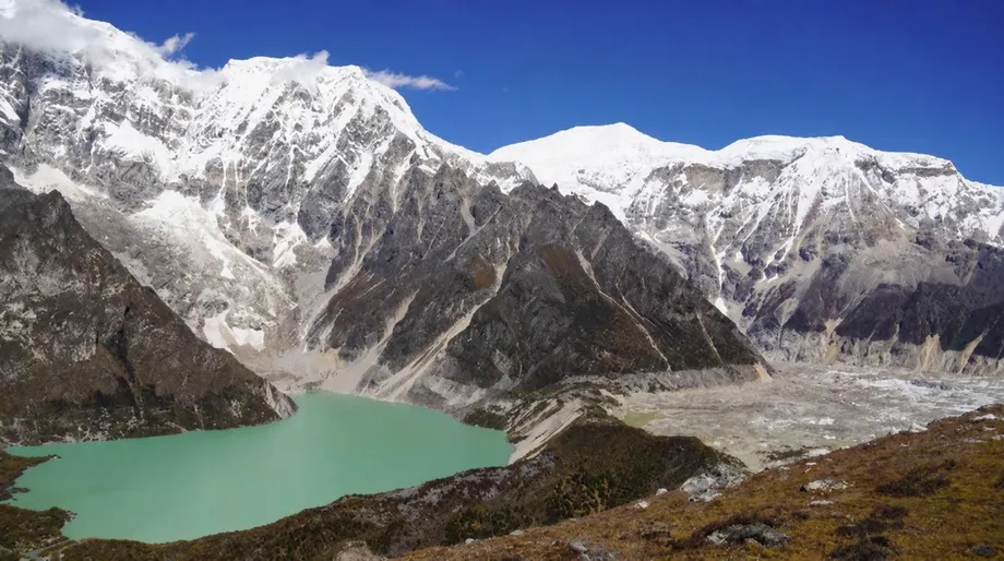
Retreating glaciers can leave depressions where meltwater collects. Some glacial lakes are held back by ridges of loose rock and sediment left by the ice. If a natural barrier fails or water spills over it, a large volume can rush downstream.
A glacial lake outburst flood is that sudden release of stored lake water. It can carry sediment and debris into valleys, putting settlements and infrastructure below the lake at risk. NCHM identifies the formation and expansion of glacial lakes as a growing hazard associated with glacier retreat.
Bhutan operates 234 NCHM observation stations and provides weather forecasts and advisories. An assessment discussed alongside the glacier measurements identified gaps in disaster knowledge, communication of warnings and preparedness, despite stronger performance in observation and forecasting.
For people downstream, a warning must reach the right community in time for a response. Monitoring mountain conditions, communicating danger and preparing residents are connected tasks. The regional stakes are substantial: floods and storms made up more than 80 percent of reported disaster events in Asia in 2023, causing more than 2,000 deaths and affecting more than 9 million people.
What the changes mean for Laya
Dorji's yak herding at Wakila places the story in a landscape where livelihoods depend directly on mountain conditions. Alpine pastures provide grazing, while water availability helps shape the surrounding environment.
For highland communities, glacier retreat is part of a changing setting for daily work. Water sources and grazing conditions affect where animals can feed and how herders maintain their livelihoods. The changes reported in Laya connect the national inventory to the practical concerns of families living close to the ice.
Bhutan faces different needs at different elevations. Highland residents depend on the local environment for livestock and household water. Downstream communities rely on river flows and face potential flood exposure. The same retreating glacier can therefore matter to a herder, a farmer and an electricity producer in different ways.
The record so far and the next scientific step
The evidence spans several overlapping observation periods. A short timeline shows how temperature records, field measurements and satellite mapping contribute to the latest picture:
- 2000 to 2025: Zanam and Lunana recorded warming of 0.79 and 0.83 degrees Celsius respectively.
- 2004 to 2020: Gangjula lost 30 percent of its ice.
- 2016 to 2025: Satellite images used for the Bhutan Glacier Inventory 2026 were collected.
- 2018: The previous national glacier inventory provided the comparison for the latest reported losses.
- 2021 to 2022: Shodug recorded a negative mass balance equivalent to about 1.76 metres of water per year.
- 2026: The latest inventory counted 673 glaciers covering nearly 572 square kilometres.
NCHM has not yet produced a projection for the future state of all Bhutan's glaciers. The centre plans to model some major glaciers because individual glaciers respond differently to warming; no completion date was given.
Those models would help connect today's measurements with future water planning and lake risk management. The inventory already provides a national map of remaining ice, while repeated measurements at benchmark glaciers show how quickly particular ice reserves are losing mass.
Key Points
- Bhutan's 2026 inventory counts 673 glaciers covering nearly 572 square kilometres.
- Since the 2018 inventory, the country has lost 27 glaciers and more than 57 square kilometres of glacier area.
- Zanam and Lunana warmed by about 0.8 degrees Celsius between 2000 and 2025.
- Gangjula lost 30 percent of its ice between 2004 and 2020, while Thana and Shodug also recorded substantial losses.
- Shrinking glaciers threaten future water supplies and hydropower, while expanding glacial lakes increase flood danger.
- NCHM plans to model major glaciers to better understand their future behaviour.