A wider warning network, with seconds to take cover
Google is expanding its Android Earthquake Alerts System from 98 countries and regions to more than 200, including Panama and Guatemala, after sending more than one billion alerts since 2021. The expansion more than doubles its geographic coverage and comes with plans to give people clearer information about shaking detected nearby.
Contents
- A wider warning network, with seconds to take cover
- When will newly covered places receive alerts?
- Three alerts for different levels of shaking
- What the new map will show
- How an ordinary phone becomes a sensor
- How the system reached this point
- What testing found about warning time
- Earthquakes in Asia show the range of results
- What users need, and how they responded
- Key Points
In its October 15 announcement, published in 2026, Google said an improved Be Ready alert would show a map of the area where shaking was detected, an estimated earthquake magnitude and recommended safety actions. Those additions are scheduled for the coming months, rather than arriving everywhere with the geographic expansion.
The service uses measurements from Android phones to detect an earthquake already underway, then sends warnings to people who may experience shaking. Its practical purpose is simple: give someone enough time to move away from a dangerous object or take cover before stronger shaking reaches them.
Google describes the service as the world's largest earthquake detection network based on mobile phones. Its research also shows why warning time varies: some people receive an alert before shaking, while others receive it during or afterward.
When will newly covered places receive alerts?
The rollout in newly supported regions began on October 15 and was expected to finish within the following week. Google named Panama and Guatemala among the additions without listing every newly covered country and region in the announcement.
Panama's president, José Raúl Mulino, announced his country's inclusion and thanked Google for its cooperation. He described the value of gaining even a little time before dangerous shaking:
A tool that allows us to gain time in the event of an earthquake, where every second counts to protect life,
Panama's precise activation date was not specified in the account of Mulino's announcement. The wider rollout schedule places the expansion within the week following October 15, while the richer Be Ready display has a separate timetable extending into the coming months.
Three alerts for different levels of shaking
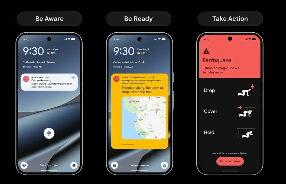
Android users in supported areas may receive one of three warnings. Google selects the warning according to the shaking expected at the user's location, so people at different distances from the same earthquake can receive different instructions.
- Be Aware tells users that an earthquake has been detected nearby and that light shaking is expected.
- Be Ready provides a more detailed warning when stronger shaking is anticipated and asks users to prepare to act.
- Take Action fills the screen and gives immediate safety guidance when moderate to heavy shaking is expected.
Google's earthquake alerts guide says warnings are sent for earthquakes of magnitude 4.5 or greater. The alert level also depends on local intensity, measured using the Modified Mercalli Intensity scale, or MMI. Magnitude describes the size of an earthquake; intensity describes how strongly it shakes a particular place.
The guide places awareness alerts at MMI 3 or 4, preparation alerts at MMI 4 during large earthquakes, and the most urgent alerts at MMI 5 or higher. The overlap reflects different warning conditions, rather than three completely separate bands of shaking.
Phone behaviour changes with urgency. Awareness alerts follow normal device settings. Preparation alerts may override silent mode. The most urgent warning overrides silent mode, turns on the screen and sounds loudly.
What the new map will show
The updated Be Ready warning will bring several pieces of information together: a radius showing where shaking was detected, an estimated magnitude, actions the user can take and a button for further information as details arrive.
Google's existing guide already describes safety information and an initial earthquake location and magnitude map available after tapping an alert. The announced update puts more useful detail into the Be Ready experience itself, where users may have only seconds to decide what to do.
A map of detected shaking and an earthquake's epicentre serve different purposes. The epicentre is the point on the surface above where the earthquake begins. A shaking map helps describe the wider area affected. Local conditions and distance influence what people feel, which is why a magnitude alone cannot tell every user how strong the shaking will be at their location.
Google's example graphic includes an estimated magnitude 6.1 earthquake about 16 miles away. The figure illustrates the planned display; the actual magnitude, distance and recommended action will depend on the earthquake detected.
How an ordinary phone becomes a sensor
Android phones contain accelerometers, small sensors that measure movement. The same sensor that helps a phone recognise when it has been turned sideways can also register ground movement when the device is stationary.
Google's July 2025 research explanation, written by Android principal software engineer Marc Stogaitis, describes how a phone can detect the first, faster seismic waves, called P waves. It sends a signal and an approximate location to Google's earthquake detection servers.
The servers combine measurements from many phones to decide whether an earthquake is happening and estimate its location and magnitude. They then try to send warnings before the slower S waves, which can produce stronger shaking, reach other users. The warning travels through communications networks faster than those seismic waves travel through the ground.
Google says more than two billion Android phones form the potential detection network. Phones are less sensitive than dedicated seismic instruments, but their large numbers allow measurements to be gathered in places where specialist monitoring networks are limited or absent.
California, Washington and Oregon use a different detection arrangement. There, Android distributes warnings using data from ShakeAlert, whose network is described in Google's guide as having 1,675 seismic sensors. Android therefore serves both as a warning delivery channel for a dedicated network and, elsewhere, as part of a detection system built around phones.
How the system reached this point
Google's expansion follows several years of operation and evaluation. Its research places the start of alerts generated by Android detections in April 2021, beginning with New Zealand and Greece. By the end of 2023, the service was active in 98 countries.
- 2019: About 250 million people worldwide had access to earthquake early warning systems, according to Google's estimate.
- April 2021: Google began rolling out alerts generated by Android phone detections in New Zealand and Greece.
- End of 2023: The Android system was active in 98 countries.
- July 17, 2025: Research published in Science assessed three years of operation, while Google published a broader update on the system.
- October 15, 2026: Google announced coverage expanding to more than 200 countries and regions and a cumulative total exceeding one billion alerts.
The July 2025 update counted more than 18,000 earthquakes detected and warnings issued for more than 2,000 earthquakes, producing 790 million individual alerts. These totals measure different things: an earthquake can be detected without requiring public warnings, while one earthquake can generate millions of notifications to phones.
Google estimated that access to earthquake early warning had grown from about 250 million people in 2019 to 2.5 billion, largely through the Android system. Those figures represent a tenfold increase. The latest geographic expansion extends the network further, although the announcement gives no revised population total.
What testing found about warning time
The Science research paper, published on July 17, 2025, examined the system across three years. It described more than 1,200 earthquake warning events during that period and an operating rate of about 60 events and 18 million individual alerts per month across 98 countries.
In Türkiye, the system detected an average of 312 earthquakes per month, ranging from magnitude 1.9 to 7.8. Detection included smaller tremors, while public alerts covered earthquakes of magnitude 4.5 or greater.
User feedback in the study found that 85% of recipients felt shaking. It also recorded 36% receiving an alert before shaking, 28% during shaking and 23% afterward. The figures show the real experience behind the promise of a few seconds of warning: arrival time depends on where a person is and how quickly detection and delivery happen.
Google faces a constant timing problem. Waiting for more measurements can improve an estimate, but it also leaves less time to warn people. The company said the median absolute error in its first magnitude estimate fell from 0.50 to 0.25 over three years. In simple terms, the middle value of those estimation errors was halved.
Earthquakes in Asia show the range of results
A magnitude 6.7 earthquake in the Philippines in November 2023 prompted the system's first alert 18.3 seconds after the earthquake began. Google said people closest to the epicentre who experienced the most intense shaking received up to 15 seconds of warning. People farther away who experienced moderate shaking received up to a minute. Nearly 2.5 million people were alerted.
During a magnitude 5.7 earthquake in Nepal that same month, the first alert went out 15.6 seconds after the earthquake began. People experiencing moderate to strong shaking had 10 to 60 seconds of warning, and more than 10 million alerts were delivered.
A magnitude 6.2 earthquake in Türkiye in April 2025 produced the first alert after eight seconds. Google reported warning times ranging from a few seconds to 20 seconds for people experiencing moderate to strong shaking, with more than 11 million alerts delivered.
Google chief executive Sundar Pichai also cited earthquakes in Venezuela when discussing the expansion. He said millions of people outside the epicentre received alerts and could take cover before shaking began. The Asian examples provide more detailed timing measurements, showing how warning time changes from one event and location to another.
What users need, and how they responded
Android users need Wi-Fi or mobile data connectivity, location settings enabled and Android Earthquake Alerts switched on to receive warnings. Google says alert delivery uses an approximate device location. Users can turn the service off in their device settings.
More than 1.5 million people responded to the survey described in Google's July 2025 research update. Of those respondents, 85% rated the alerts very helpful. Among people who received an alert but felt no shaking, 79% still gave that rating.
People receiving Take Action warnings reported strong shaking more often than those receiving Be Aware alerts. Google also said the most common response among Take Action recipients was to drop, cover and hold on, the protective action intended to reduce exposure to falling objects during shaking.
The expanded network gives more communities access to that warning process. Its usefulness rests on several steps happening quickly: phones detecting movement, servers estimating the earthquake, a connected device receiving the alert and a person acting on the guidance. The new Be Ready display aims to make that last step easier by putting the estimated magnitude, affected area and recommended response together.
Key Points
- Google announced expansion from 98 countries and regions to more than 200 on October 15, 2026, including Panama and Guatemala.
- The system has sent more than one billion individual alerts since 2021.
- New regions were expected to receive the service within the week following October 15.
- A richer Be Ready warning, including a shaking map, estimated magnitude and safety actions, is planned for the coming months.
- Warnings require connectivity, enabled location settings and Android Earthquake Alerts switched on.
- Research recorded alerts arriving before, during and after shaking, with warning time varying by earthquake and location.