773.9 hectares buried, and a recovery measured in more than concrete
A year after the September 23, 2025, flood killed 19 people and left five missing in Taiwan's Guangfu Township, Indigenous communities along Matai'an Creek face another upheaval: flood protection projects could permanently change where they live, what land they own and whether they can farm again.
Contents
- 773.9 hectares buried, and a recovery measured in more than concrete
- What happened when the mountain lake failed?
- New embankments do not resolve every flood route
- Some residents seek relocation, while others fear forced removal
- Land acquisition reaches into generations of farming
- Returning to cultivation is not the same as restoring income
- Forest plans bring a different future for damaged fields
- New farmland requires investment and secure access
- Researchers are tracking a river that continues to change
- Participation and government responsibilities remain unsettled
- Key Points
The Executive Yuan counted 773.9 hectares of farmland buried by sediment. Only roughly a third has returned to cultivation, with yields still struggling. Upstream, about 230 million cubic metres of unstable material remain. The Water Resources Agency plans to acquire 340 hectares for temporary sediment storage as part of a wider river corridor, while separate plans would turn severely damaged farmland on the southern bank into forest.
These measures address a real danger. Heavy rain can move sediment downstream, raise riverbeds and reduce the space available for floodwater. Residents nevertheless say construction has advanced faster than answers about drainage, relocation, compensation and Indigenous participation.
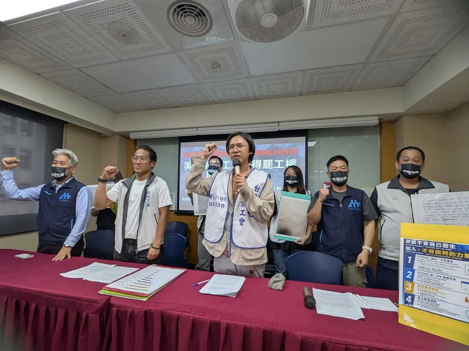
On September 21, 2026, residents from six communities travelled to the Executive Yuan with sediment from the disaster area. Their message was that rebuilding the river cannot be separated from rebuilding their lives. Some households want help moving to safer ground nearby. Others fear losing homes that survived the original flood because those properties now lie in the path of new defenses.
What happened when the mountain lake failed?
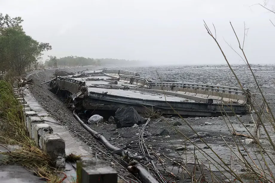
Rain from Typhoon Ragasa's outer circulation caused the natural dam upstream of Matai'an Creek to fail. A landslide dam forms when fallen rock and soil block a river, creating a lake whose barrier can erode rapidly once water flows over it.
Early estimates placed the start of the breach at about 3:50 p.m. on September 23. Around 15.4 million cubic metres of water were estimated to have escaped, mostly within approximately 30 minutes. The resulting channel may have reached 80 metres deep. Early accounts also suggested peak flow was about four times greater than anticipated, although that estimate was not presented as a settled measurement.
The human toll changed as information emerged. An early account attributed 15 deaths and 17 missing to Interior Minister Liu Shyh-fang, while other initial reports put the missing count as high as 31. The anniversary account gives 19 deaths and five missing. These figures describe different reporting stages, rather than an unchanged casualty count.
Key dates show how the emergency developed into a prolonged reconstruction dispute:
- September 23, 2025: The dam failed, sending floodwater and debris into Guangfu and nearby communities.
- October 2, 2025: Indigenous representatives called for participation in resettlement planning, safe conditions for volunteers and proper shelter.
- May 15, 2026: Intense rain caused Madana Creek to flood homes through a construction opening.
- July 2026: Kalotongan residents evacuated to the former Dongfu Elementary School as Typhoon Bavi approached.
- August 2026: The Executive Yuan approved a draft amendment to recognize landslide lakes as a statutory disaster category.
- September 21, 2026: Six communities petitioned the Executive Yuan over land, housing, livelihoods and reconstruction decisions.
New embankments do not resolve every flood route
Atomo lies near the meeting of Matai'an Creek and the Hualien River. Residents trace part of their exposure to a northern embankment built in the 1990s, which narrowed the river corridor and placed their community directly in the path of floodwater.
During the 2025 disaster, thick mud engulfed homes near the river. Some residents abandoned repairs. Others worked on their houses by day and slept in temporary accommodation at night. Even people who returned home remained ready to evacuate whenever rain intensified.
Sediment has also accumulated where four tributaries from the Coastal Mountain Range meet the Hualien River. The Water Resources Agency is dredging and building embankments along the lower tributaries to prevent water from the main river pushing back upstream. Yet the May 15 flooding showed how vulnerable households remain during construction: water entered through a gap and soaked recently repaired homes and new furniture.
Kalotongan faces a related but distinct problem. Parts of the community flooded to roughly the height of one storey in September 2025. Residents say the Hualien River's bed now stands above the nearby Luomo Creek. A barrier might keep river water out while also making it harder for rainwater inside the settlement to drain.
The Water Resources Agency says any pumping station or detention basin needed after the embankment is completed must be planned by the county government. That division of responsibility leaves an unresolved practical issue: protection against outside water is incomplete if water accumulating inside a community has no reliable exit.
Residents also fear that flooding could cut County Road 193 and block evacuation. Downstream, people around Jianying Bridge and the same road want an explanation of how stronger upstream defenses might affect their own exposure.
Some residents seek relocation, while others fear forced removal
Kalotongan resident Dongi, also known as Li Yu-lan, says the community first asked about relocation more than 20 years ago. There is still no clear plan. Residents have proposed unused Taiwan Sugar Corporation land beside Dongfu Elementary School, less than 500 metres from their current settlement, as a possible destination.
The proposal would allow households to move away from danger without dispersing far from their community. Hualien County's response was to refer the matter to Guangfu Township authorities. No agreed resettlement site or timetable is described.
Elsewhere, relocation is something residents may be required to accept rather than something they have requested. Li Lan-hsiang and Meng Ying-hua, residents of the Xiangcaochang area, say some homes that did not flood in September 2025 could be demolished for the proposed second southern defense line. They want the government to explain the route, alternatives and, if a move is unavoidable, a specific place to live.
The concern about keeping communities together was voiced just days after the disaster. Kulas Umo, a representative of the Fata'an Self-Help Group, argued that Indigenous residents must help shape resettlement rather than receive a finished plan.
Discussions regarding resettlement, whether in the mid-term or the long-term, must include Indigenous voices. If the plans are finalized without our participation, we're left with no choice but to accept them passively.
Drawing on the experience of Typhoon Morakot, Kulas Umo also warned that scattering Indigenous communities weakens cultural cohesion and affects mental health. The dispute is therefore about the location and continuity of communities, not simply the provision of replacement buildings.
Land acquisition reaches into generations of farming
The Water Resources Agency proposes extending the northern management corridor inland by 740 metres and acquiring 340 hectares for temporary sediment storage. On the southern side, it plans a second embankment within a corridor extended by 200 metres.
Residents say roughly 90 percent of Indigenous reserve land on the northern bank falls within the proposed acquisition area. These fields were once part of a floodplain and have been cultivated for generations. After embankments were built in the 1990s, residents fought to secure their designation as Indigenous reserve land.
The agency says privately owned land will be acquired at market prices. However, some people cultivating reserve land have not obtained ownership because government application procedures remain delayed. That creates uncertainty over how their interests would be recognized during acquisition.
Landholders have proposed exchanging affected plots for other land instead of receiving only cash. The Water Resources Agency says such exchanges fall outside its authority. Residents also allege that construction and sediment storage began on private property before owners consented or fully understood the procedures.
The scale of sediment management explains the pressure for space but does not settle those disputes. The agency reports having dredged 22.95 million cubic metres after the disaster. Current annual dredging is about 10 million cubic metres, compared with about 3 million cubic metres of material finding an outlet. On those figures, roughly 7 million cubic metres a year would still require storage or another destination.
A separate description gives the remaining amount as 7 million tonnes. Tonnes measure mass, while cubic metres measure volume; the figures cannot be treated as equivalent without knowing sediment density. Dust, noise and heavy construction traffic are already affecting nearby households.
Returning to cultivation is not the same as restoring income
Of the 773.9 hectares damaged, the Executive Yuan classified 555.3 hectares as generally affected and 218.6 hectares as severely affected, using sediment depth around 50 centimetres as the dividing line. The severe category accounts for about 28 percent of the total.
After excluding land within the river management corridor, about 380 hectares in the generally affected category need help returning to cultivation. The agricultural recovery program distinguishes lighter deposits below 20 centimetres from moderate deposits between 20 and 50 centimetres. Farmers can seek organic fertilizer support or assistance from the Hualien District Agricultural Research and Extension Station.
Ni Li-feng, an associate researcher at the station, reported applications covering about 170 hectares. Preliminary mapping suggested approximately 150 hectares with lighter damage and 50 hectares with moderate damage. Those estimates total 200 hectares, more than the application figure, and still require field checks. They should not be read as a reconciled final inventory.
The station aims to finish improvement of lightly affected soils in October 2026, with moderately affected areas expected to take until the end of 2027 because deeper work and excavators are needed.
Farmer Lo Jen-ming's former rice fields were buried under 20 to 40 centimetres of sediment, and irrigation infrastructure was damaged. After organic material was added to the soil, he tried growing maize. Yields remained disappointing, and he took casual work to support his household.
Lo estimates that soil recovery will take at least three years and wants fertilizer subsidies to continue. His experience shows why a field counted as cultivated again may still be far from supporting its owner. Across the area, the reported return of cultivation on a little over 200 hectares, described as roughly a third of damaged farmland, does not establish that farm earnings have recovered.
Forest plans bring a different future for damaged fields
About 163 hectares of severely damaged farmland outside the river management corridor are considered difficult to restore. Some plots lie beneath as much as eight metres of sediment, mixed with timber and stones. Removing everything would be difficult, and the alkaline soil is poorly suited to immediate cultivation.
The southern bank's severely affected farmland is slated for acquisition and forest planting. The Agency of Rural Development and Soil and Water Conservation is planning a forest memorial park with a commemorative plaza, a low grassed area for flood detention, and cycling and recreation paths. The Forestry and Nature Conservation Agency would handle subsequent planting on 141 hectares. That figure describes its planting assignment, not the entire 163 hectares identified as difficult to farm.
A 1.5 hectare tree trial was completed in March 2026. Another trial, covering about 0.5 hectares, is planned for March 2027, combining taller trees with lower vegetation and native shrubs. The intended functions include a flood buffer and reduced blowing sediment.
On the northern bank, the approach is chiefly subsidized tree planting rather than blanket acquisition. The reported maximum is NT$600,000 per hectare over six years. However, the stated schedule of NT$250,000 in year one and NT$60,000 annually in years two through six adds up to NT$550,000. The difference is not explained.
Farmer Huang Chun-lung wants consultation over the park and questions whether forestry payments can replace rice earnings. He gives former annual rice revenue of nearly NT$300,000 per hectare, against NT$60,000 in annual forestry support after the first year. That payment is about one fifth of the stated rice revenue, although revenue and a subsidy are not equivalent measures of profit.
New farmland requires investment and secure access
The Ministry of Agriculture has identified public and publicly operated land for displaced farmers, with rent and planting support. Rent assistance is capped at NT$40,000 per hectare annually and is scheduled to run through the end of 2030.
Farmer Yang Chin-wen leased 6.8 hectares of Taiwan Sugar land near Danong Dafu to plant maize. Four months of clearing stones completed only about a third of the site. He estimates that preparation of the whole area will take a year and worries that uncertain future access could undermine the money and labor invested.
At Pangcah Farm, operator Su Hsiu-lien has resumed cultivation on fewer than two of the original 4.7 hectares. About 1.2 hectares were too severely buried to restore. Her efforts include organic fertilizer, soil improvement, organic soybeans and drip irrigation installed with the Industrial Technology Research Institute.
She is also continuing to grow a native crop known as marriage beans, which she found suited to the damaged ground. That work links agricultural recovery with cultural transmission. Replacement acreage alone does not answer whether farmers can sustain familiar crops, practices and income.
Researchers are tracking a river that continues to change
Monitoring through July 2026 put about 130 million cubic metres of sediment in the original collapse area and another 100 million cubic metres in the residual dam and channel. Yang Che-ming, an associate professor at National Taiwan University of Science and Technology, identifies the residual dam area as the least stable.
Research by National Yang Ming Chiao Tung University describes two main risks: new collapses could form another lake holding as much as 8 million cubic metres, or moving sediment could raise the channel and reduce its capacity to carry floods. September aerial images showed the old lake area had returned to a river channel, but that did not remove these threats.
National Cheng Kung University has established a science station in Guangfu. Researchers collected more than 1,000 kilograms of sediment from over 100 locations and installed automatic sediment concentration monitoring at a temporary steel bridge. The measurements are intended to improve simulations and produce village risk maps.
At National Chung Hsing University, a model at one fiftieth of the original scale suggested that the 2025 breach involved both erosion cutting down through the upstream overflow and erosion advancing upstream from below. A long natural dam can therefore fail quickly through processes acting from both directions.
Monitoring limits were exposed again after a landslide lake formed on Wanli Creek on June 21, 2026. An instrument deployed on June 28 showed the lake was less than 60 percent full, after a red alert had already prompted evacuation. Before Taiwan purchased a second deployable water gauge on July 8, there was no replacement while the first instrument needed repairs.
Researchers are testing optical fiber to detect changes in dam strain and water level. These methods remain under development. Better measurements can narrow uncertainty, but they cannot guarantee a single predicted outcome or eliminate the need for precautionary evacuation.
Participation and government responsibilities remain unsettled
The September petition came from Fata'an, Tafalong, Atomo, Kalotongan, Cirakayan and Cihafayan. Their youth alliance sought early Indigenous participation, clear information in accessible language, a survey of public and Taiwan Sugar land, alternatives to acquisition, coordinated responsibilities and continued housing support.
It also asked that nonurgent acquisition and relocation not proceed before drainage risks, sediment analysis, engineering necessity and alternatives are explained. Residents distinguish emergency protection from permanent projects that determine future land use.
National Chengchi University professor Kuan Da-wei called for explanations of the second defense line and potential downstream effects. Scholars Li Ming-chih and Lin Chun-ju raised alternatives to acquisition and the possible application of consultation and consent procedures under Article 21 of the Indigenous Peoples Basic Law.
Public Construction Commission Deputy Minister Lee Yi-te said comprehensive engineering planning had been commissioned from Sinotech Engineering Consultants and that communities and relevant agencies would be included. Council of Indigenous Peoples Deputy Minister Ljaucu said only two cases had been submitted for assessment of whether consultation and consent were required. There was no agreement on pausing permanent projects or acquisition while that issue was clarified.
Experts have also proposed using Article 8 of the Spatial Planning Act for a special regional plan covering the river basin across administrative boundaries. No discussion of that route had begun within the land planning administration during the first year described in the anniversary account.
The Executive Yuan's August disaster law amendment remains a draft, not a confirmed enacted change. It would make the Ministry of Agriculture responsible for landslide lake disasters. No legislative vote date is given. Residents still lack firm answers on relocation, land exchanges, drainage facilities and the timing of lasting livelihood support.
Key Points
- The anniversary account records 19 deaths and five missing after the September 23, 2025, flood.
- About 230 million cubic metres of sediment remain upstream, creating continuing flood and collapse risks.
- Of 773.9 hectares of damaged farmland, roughly a third has returned to cultivation, with income and yields still affected.
- A proposed northern sediment storage area would require 340 hectares; separate southern farmland plans involve acquisition and forest planting.
- Residents seek clear drainage and relocation plans, alternatives to land acquisition and meaningful Indigenous participation.
- Soil work extends into 2027, while alternative farmland rent support is scheduled to end in 2030.