In Bedono, relief from floods comes with a cost
On many mornings, Ms Pangestuti cooks while standing knee deep in seawater inside her home in Bedono village, on the north coast of Central Java. Tidal flooding has entered her house for years. She hopes a seawall now being built between Semarang and Demak will bring relief.
Contents
- In Bedono, relief from floods comes with a cost
- Why the water keeps advancing
- A barrier must also let water out
- Different defenses for different stretches of coast
- Jakarta and Demak provide the starting points
- A new authority will coordinate the work
- Who will pay for construction and upkeep?
- Safety, food and coastal livelihoods
- Key Points
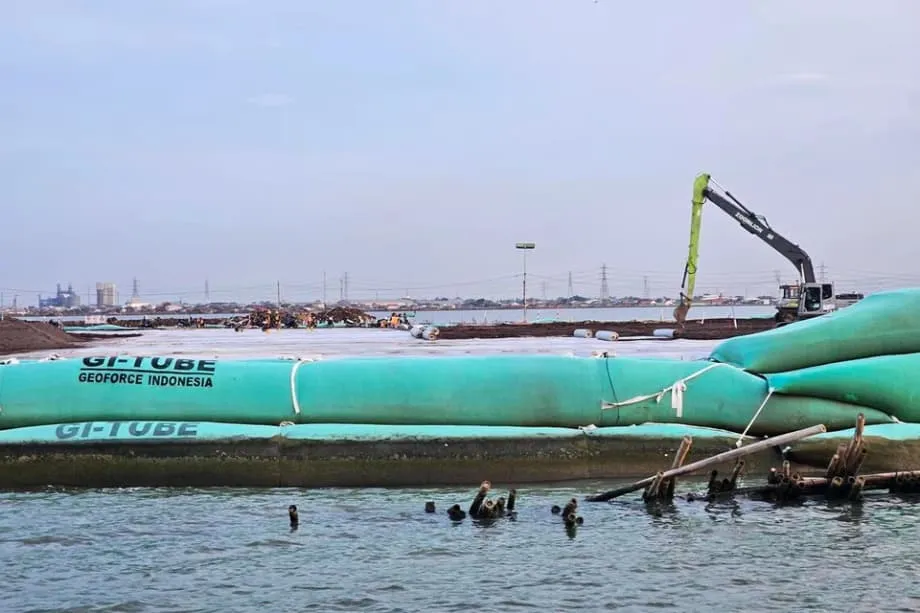
The structure stretches 6.7 kilometers and doubles as a toll road. As of October 15, 2025, construction is about halfway complete, with completion targeted for 2026. For households living with regular inundation, the barrier offers the prospect of protection that they say is overdue.
Small boat fishers see a different side of the work. They say their catches have plummeted since construction began. The first stretches of the coastal defense have already exposed a difficult balance: protecting homes from the sea while keeping fishing communities and coastal ecosystems viable.
Indonesia is preparing to extend that challenge across much of Java's northern shoreline. Its proposed giant sea wall would run from Banten in the west to Gresik in East Java, protecting a crowded corridor of homes, factories, ports and transport routes.
Depending on the final design, the wall and related defenses could cover roughly 500 to 700 kilometers. Some proposals stretch closer to 900 kilometers. The expected cost runs to tens of billions of dollars, with estimates reaching $80 billion, and work would unfold over 15 to 20 years.
Close to 50 million people live near this shoreline, alongside dozens of industrial estates, ports and logistics hubs. Their concentration makes both flooding and construction consequential. The government's task is to provide protection in ways that allow communities, ecosystems and economies to remain viable.
Why the water keeps advancing
Semarang is among several cities on Java's north coast that have sunk after decades of heavy groundwater pumping. When the ground drops while the sea rises, water can reach farther inland and remain there longer. Residents experience both changes together, even though they have different causes.
Scientists describe the coast's predicament as a double exposure. Indonesia's Meteorology, Climatology and Geophysical Agency, known as BMKG, has reported an average sea level rise of around 4.3 millimeters a year since the early 1990s, with the pace increasing in recent years.
Land subsidence, the sinking of the ground, can move much faster. Studies in Jakarta, Pekalongan, Semarang and Demak have found that some districts are sinking several centimeters a year, at least nine times faster than current global sea level rise. In places, the sea's level relative to the shoreline has climbed by as much as two meters.
Groundwater extraction is the biggest driver. Industries, commercial complexes and households pump underground water, often because reliable piped supplies are unavailable. When water is removed from aquifers faster than it is replaced, layers of clay and sand compress. The surface above them then sinks.
Heavy buildings and roads add pressure. Many neighborhoods along the coast also stand on soft alluvial soils, which compact under that weight. Tidal surges, heavy river runoff during wet seasons and storm waves bring further water into places already losing height.
A barrier must also let water out
Parts of the northern coast already have embankments, pumps and polders. A polder is an area where water is held back and drainage is managed. Pumps move collected water toward the sea at low tide.
Those defenses depend on more than the strength of a wall. Drainage channels must remain open, pumps need maintenance, and rivers need room to discharge. Where river mouths fill with sediment, or structures block the movement of water, inland flooding can become more frequent and damaging.
A new coastal barrier must therefore account for water arriving from two directions: the sea outside and rivers and drainage channels inland. The design also needs to consider how rivers, wetlands and the ocean move sediment along the coast.
For communities behind the defenses, that means protection depends on a working system of barriers, gates, pumps and drainage. Each part affects whether water can leave the land as well as whether seawater can enter it.
Different defenses for different stretches of coast
The government says the northern coastline will receive defenses suited to local conditions. Urban stretches such as Jakarta and Semarang would have engineered barriers, pumps and polder systems. Other densely populated areas, or places containing valuable infrastructure, could receive sea walls, surge barriers, gates, pump stations and improved drainage.
Less populated stretches could see dikes, the movement of homes and farms inland, and mangrove restoration. Moving inland, sometimes called managed retreat, would place those homes and farms farther from the advancing water.
Mangroves offer another form of protection. They can reduce wave energy and trap sediment, helping land build naturally. In some zones, broad, hilly dikes would stand inland from the shore to keep critical districts dry.
The final design remains unsettled, reflected in the different estimates for the project's length and cost. The proposal covers a combination of walls and related defenses, with the approach changing from place to place.
Jakarta and Demak provide the starting points
The larger proposal draws on coastal protection efforts around Jakarta Bay that began a decade ago, alongside more recent construction such as the Semarang Demak barrier. The Jakarta segment alone could take eight to ten years and cost an estimated $8 billion to $10 billion.
The government intends to bring previous studies together, including the long discussed National Capital Integrated Coastal Development plan, known as NCICD, for Jakarta. A masterplan would set the order of projects and weigh the competing needs at each location.
Planning for coastal defenses has a much longer history than the current construction. Regional proposals have been discussed in some form since the mid 1990s. The new program seeks to coordinate those plans across a much larger area.
The main stages and time estimates are:
- Since the mid 1990s: regional coastal protection plans have been discussed in some form.
- About a decade before October 2025: earlier efforts around Jakarta Bay began.
- October 15, 2025: the 6.7 kilometer Semarang Demak seawall and toll road is about halfway built.
- 2026: the targeted completion year for the Semarang Demak structure.
- Eight to ten years: the estimated construction period for the Jakarta segment.
- Fifteen to twenty years: the expected period for work on the wider northern coast program.
A new authority will coordinate the work
President Prabowo Subianto established the North Java Coast Seawall Authority to oversee planning, finance and construction. Retired Vice Admiral Didit Herdiawan Ashaf was appointed to lead it.
The authority's mandate includes coordinating plans and budgets across provinces and ministries, bringing earlier studies together and adjusting designs as conditions change. It intends to produce the masterplan that will guide the sequence of construction and the choices made at individual locations.
Coordination matters because the program spans cities, rural districts, rivers, wetlands and industrial areas. A defense designed for a dense urban district will serve different needs from one protecting farms or fishing villages. The authority must connect those local decisions within a coastal program stretching across Java.
Who will pay for construction and upkeep?
The government plans to draw on several sources of finance. It has encouraged public private partnerships and invited interest from partners in Asia and Europe. Under such partnerships, government and private participants would share roles in supporting the project.
Indonesia's state investment agency has been tasked with exploring arrangements that combine assets capable of earning revenue, partnerships and land value capture. Land value capture means using some of the increase in land values associated with a project to help pay its costs.
The financing effort must support construction, operations and maintenance. Keeping pumps working and drainage channels open will remain part of the cost after a barrier is built.
The national plan presents the sea wall as a signature climate adaptation project and a means of protecting vital transport and industrial corridors. Its role as an economic defense sits alongside its purpose of reducing the danger faced by coastal households.
Safety, food and coastal livelihoods
Senior officials describe protecting people along the coast as both a moral and practical duty. They argue that doing little or nothing would leave millions exposed to daily risk, while acknowledging that major infrastructure affects the places where it is built.
Food security is also part of their case. Rice fields, aquaculture ponds and fishing communities occupy large stretches of Java's northern coast. Flood protection therefore concerns the land and water people use to produce food, as well as the houses where they live.
Agus Harimurti Yudhoyono, the coordinating minister responsible for infrastructure and regional development, has placed the sea wall within a broader national effort to adapt to climate change and keep coastal communities safe. His rationale extends beyond the concrete structures to the people they are intended to protect.
Bedono brings those competing needs into focus. Ms Pangestuti hopes the Semarang Demak barrier will ease years of flooding inside her home. Small boat fishers say catches have fallen sharply since construction started. Both experiences belong at the center of decisions about how the coast is defended.
The wider program seeks to protect nearly 50 million coastal residents and an important economic corridor through a mix of engineered defenses, drainage, mangroves and changes in where people live and farm. Whether a particular stretch needs a wall, a dike or another approach will shape daily life on both sides of the protection.
Key Points
- The Semarang Demak seawall and toll road is 6.7 kilometers long, about halfway built and targeted for completion in 2026.
- The wider proposal runs from Banten to Gresik, with estimates of roughly 500 to 700 kilometers and some proposals closer to 900 kilometers.
- Costs could reach $80 billion, with work expected to unfold over 15 to 20 years.
- Sea level rise and rapidly sinking land are increasing flood exposure along Java's northern coast.
- Defenses would vary by location, combining barriers, pumps, drainage, dikes, mangroves and movement inland.
- Retired Vice Admiral Didit Herdiawan Ashaf leads the new authority coordinating the program.
- Residents seeking relief from flooded homes and fishers reporting falling catches face different consequences from the construction.