A changing rain belt extends Korea's summer risks
The weather front that helps bring summer rain to East Asia has shifted about 213 kilometres north during September 10 to 30, moving from the Yangtze River basin and waters south of Jeju Island toward the southern Korean Peninsula. A study covering 1979 to 2025 links that shift to a greater likelihood of rainy days arriving with oppressive, humid heat.
Contents
- A changing rain belt extends Korea's summer risks
- Why the location of a front matters
- How researchers followed 47 years of weather
- The northward shift grows toward September
- Humidity helps rain and heat overlap
- What the eight to 19 times increase means
- Warmer seas and changing winds are linked to the shift
- Recent extremes show what is at stake
- September preparedness needs to cover both hazards
- Key Points
Researchers from the Korea Advanced Institute of Science and Technology (KAIST) and the APEC Climate Center found that days with both precipitation and heat stress above normal were about eight to 19 times more frequent in late summers when the front lay farther north than in years when it stayed farther south. After removing the gradual trends across the study period, the difference was still about three to nine times.
The findings put September at the centre of a practical warning: flood prevention and protection against heat illness need to continue together after the main Changma rainy season ends. The changing position of the front affects both where rain falls and where warm, moisture laden air gathers.
KAIST's research announcement describes an analysis of 47 years of climate data. The study, titled Recent change in northward migration of the East Asian summer front and increased compound wet–hot conditions, was published in npj Climate and Atmospheric Science.
Why the location of a front matters
A weather front is a boundary between air masses with different temperatures and moisture levels. In East Asia, warm, humid air from the south meets cooler air from the north. Air can rise along that boundary, allowing moisture to condense into clouds and rain. Korea's familiar Changma front is one example.
Fronts account for about 40% of East Asia's total summer precipitation. Their share rises to about half in June and September. Moving this boundary therefore changes the position of a major source of regional rainfall, even before any change in the strength of individual downpours is considered.
Earlier research concentrated mainly on how intense rain along fronts had become. The new analysis examines where those fronts are located. For communities facing flooding or humid heat, the position of the boundary can be as consequential as the amount of rain it produces.
During the main rainy season, a front farther north was associated with more rain in northern areas, including the Korean Peninsula, and greater heat stress farther south. In late summer, the Korean Peninsula experienced a stronger overlap between rain and heat.
How researchers followed 47 years of weather
The team used ERA5, a climate reanalysis dataset produced by the European Centre for Medium-Range Weather Forecasts. Reanalysis combines historical observations with a weather model to build a consistent picture of past atmospheric conditions. The dataset used here had a resolution of about 25 kilometres.
An automated detection program located fronts every six hours across 1979 to 2025. The researchers checked the detected boundaries against front positions on weather maps and found good agreement. That repeated tracking allowed them to examine seasonal movement across decades rather than rely on a few memorable storms.
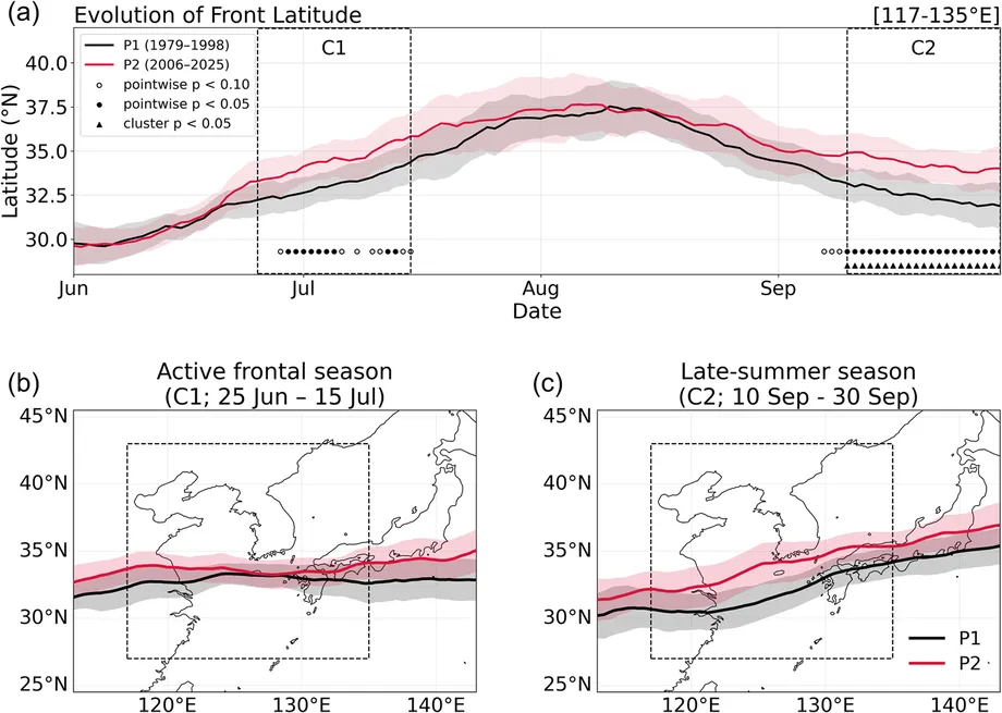
The study compared two periods of equal length: 1979 to 1998 and 2006 to 2025. Across summer, the front in the more recent period lay farther north. The largest displacement occurred toward the end of the season.
Suyeon Moon of the APEC Climate Center was the first author and a corresponding author. The other researchers were OkYeon Kim of the centre and Hyungjun Kim, a KAIST professor in the Department of AI and Futures Studies and director of the KAIST Institute for Climate, Environment and Energy. Hyungjun Kim was also a corresponding author.
The northward shift grows toward September
During the peak frontal season, June 25 to July 15, the average position moved north by about 146 kilometres, or 1.32 degrees of latitude. During September 10 to 30, the displacement reached about 213 kilometres, or 1.92 degrees.
The late summer shift was therefore 67 kilometres greater, about 46% larger than the shift during the peak rainy season. Both figures compare the same earlier and more recent periods, making the contrast a useful measure of how strongly the change is concentrated toward September.
Monthly averages show the same progression. The front moved north by about 0.26 degrees of latitude in June, 0.55 degrees in July, 0.85 degrees in August and 1.72 degrees in September. Those figures cover whole months; the larger September figure of 1.92 degrees applies specifically to September 10 to 30.
The dates and periods behind the findings are:
- 1979 to 1998: the earlier comparison period, when the late summer front lay around the Yangtze River basin and south of Jeju.
- 2006 to 2025: the recent comparison period, when the late summer front extended toward southern Korea.
- June 25 to July 15: the peak frontal season, with an average northward shift of 146 kilometres.
- September 10 to 30: the late summer window, with an average northward shift of 213 kilometres.
Humidity helps rain and heat overlap
In late summers with a front farther north, precipitation associated with fronts increased over the Korean Peninsula while the heat stress index rose by more than 0.4°C. The combination matters because damp air makes it harder for the human body to release heat.
The researchers measured heat stress using wet-bulb globe temperature, or WBGT. This index considers humidity and other environmental conditions alongside air temperature. Ordinary temperature describes how warm the air is; WBGT helps describe the heat burden on a person exposed to those conditions.
Sweat cools the body as it evaporates. When the air is already humid, evaporation slows, making cooling more difficult and increasing the risk of heat illness. A rainy period can therefore remain physically stressful even when the temperature alone seems less striking.
The team also used observations from the Korea Meteorological Administration's Automated Synoptic Observing System to examine relationships between front position, rainfall and temperature. A front farther north was associated with stronger rainfall in central Korea and higher temperatures in southern areas and along the east coast.
What the eight to 19 times increase means
The study's central comparison concerns days when two conditions occurred together: precipitation above normal and heat stress above normal. Such days were about eight to 19 times more frequent in late summers with a front farther north than in those with a front farther south.
The thresholds in that comparison were normal precipitation and heat stress levels. The figures describe the frequency of their overlap, while the broader disaster concern is that intense rain and dangerous heat can also affect the same communities during late summer.
The researchers repeated the calculation after removing the gradual changes across the decades. This statistical step separates the steady background trend from variations associated with the front's position. The remaining frequency ratio was about three to nine times, showing a strong relationship between front location and the overlap of wet and hot conditions.
For emergency planning, that overlap creates a combined problem. A period requiring flood precautions can also require continued attention to heat illness. The study recommends treating those demands together rather than assigning them to separate parts of the summer calendar.
Warmer seas and changing winds are linked to the shift
The researchers linked the movement of the front to warmer sea surfaces, increased transport of water vapour and changes in atmospheric circulation. Warm seas can supply moisture to the atmosphere, while winds determine where that moisture travels and where contrasting air masses meet.
During the main rainy season, the associated warmer waters extended from the mouth of the Yangtze River toward seas south of Japan. In late summer, the pattern involved waters around the Korean Peninsula and east of Japan, alongside stronger circulation around areas of high pressure and weaker winds high in the atmosphere.
The North Pacific high pressure system is part of that circulation. Changes in its strength can alter the movement of warm, humid air. The upper level jet, a band of fast winds high above the ground, is another part of the atmospheric pattern examined by the team.
The researchers plan climate model experiments to investigate the causes of the shift, including the role of global warming. The present analysis maps statistical relationships in historical climate data; the experiments are intended to test how particular ocean and atmospheric changes produce the observed movement.
Recent extremes show what is at stake
KAIST cited the summer of 2024 as an illustration of Korea's exposure to intense rain and prolonged heat. Gunsan recorded 131.7 millimetres of rain in one hour, described in the announcement as its highest hourly total on record. More than 600 millimetres fell over the Seoul metropolitan area in two days.
September brought further extremes. Seoul received its first heat wave warning for that month, while late September downpours in southern Korea included an hourly total of 112.2 millimetres in Jindo, South Jeolla Province. The southern flooding displaced more than 1,500 people.
Those events show why a seasonal boundary matters to residents and public authorities. The end of the main rainy season can be followed by further dangerous rain, while the heat burden continues into a month often associated with autumn.
September preparedness needs to cover both hazards
Hyungjun Kim, the KAIST professor who led the university's team, described how movement of the rain belt changes the timing and geography of summer conditions:
Changes in both the intensity and location of rainclouds are altering where and when rain and heat occur.
Kim called for September to receive more attention in disaster planning. Moon, the study's first author at the APEC Climate Center, also urged an integrated approach to heat waves and concentrated rainfall as summer hazards continue later into the year.
The practical change is a longer period of coordinated readiness. Flood prevention and heat illness management need to remain active through late September, rather than winding down solely because the main Changma period has passed.
The study adds a geographical measure to that planning problem: a late summer front averaging 213 kilometres farther north brings the boundary responsible for much of East Asia's rain closer to southern Korea. Tracking its position alongside rainfall intensity and heat stress can help authorities assess when the two hazards are likely to overlap.
Key Points
- The late summer front moved about 213 kilometres north when 2006 to 2025 was compared with 1979 to 1998.
- The shift during June 25 to July 15 was smaller, averaging about 146 kilometres.
- Researchers tracked fronts every six hours using 47 years of ERA5 climate data.
- Late summers with a front farther north had heat stress index increases above 0.4°C over Korea.
- Days with both precipitation and heat stress above normal were eight to 19 times more frequent, or three to nine times after removing long term trends.
- The team recommends combined flood and heat preparedness through late September and plans climate model experiments to investigate the causes.