Cracked hills and altered streams deepen concern
At Mon headquarters in Nagaland, an automatic weather station recorded 83.95 millimetres of rain on July 19, 2026, and 341 mm between July 19 and 31. The official disaster briefing describes landslides and flash floods on July 19 and 20 that killed residents, destroyed homes and farmland, and blocked critical roads. Weeks later, accounts of disappearing streams, new ponds and shifting slopes around Tamlu in neighbouring Longleng district have raised a harder question: whether the disaster ended with the initial collapses.
Contents
- Cracked hills and altered streams deepen concern
- Death and housing figures remain inconsistent
- Broken roads turn local damage into isolation
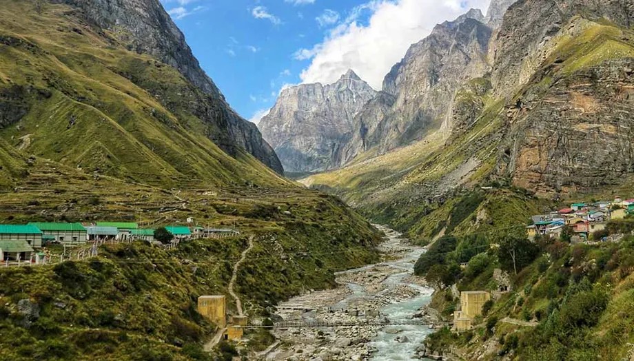
- Watercourses change on both sides of the Dikhu
- Rain is the strongest identified trigger
- Why Noklak is a warning, not a forecast
- Construction and mining claims need testing
- A wider disaster strains recovery
- Relief advances, but ground safety is unresolved
- What to Know
During an August 5 visit by Union Health and Family Welfare Minister Jagat Prakash Nadda, Mon Deputy Commissioner Wennyei Konyak reported extensive damage to roads, bridges and public infrastructure, displaced families, and interruptions to water and electricity supplies. Nagaland's Department of Information and Public Relations recorded the visit and rainfall measurements in its Mon disaster briefing.
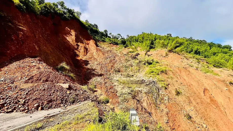
Residents describe damage extending beyond familiar landslide locations. Wanthah, a 43 year old Tamlu resident, identified Nyeichong ward as the town's worst affected area and said he had never witnessed a comparable disaster there. Houses and roads cracked as sections of the surrounding slope appeared to move downhill.
Longleng Deputy Commissioner W Manpai Phom said every village in the district suffered damage. Tamlu sustained particularly severe losses, while Yongnyah, across the Dikhu River, also experienced extensive destruction. Several villages were isolated for four to five days.
The concern is grounded in nearby experience. Noklak has endured an expanding landslide since 1980, while instability originating in Tuensang's Phinjang colony in the late 1990s has spread to other locations. Geologists nevertheless caution that cracks in Tamlu do not establish that it is entering the same prolonged process.
Death and housing figures remain inconsistent
Accounts of casualties in Mon do not agree. The Nagaland State Disaster Management Authority (NSDMA) reported nine deaths, including five in Shantham ward, and four people missing. A separate district account described eight victims, with six bodies recovered and a mother and son still missing. Those figures cannot be combined into a confirmed total.
Yoam Konyak, action secretary of the Konyak Students' Union, described a slope collapsing below an Assam Rifles camp on July 19 and taking 10 to 12 houses with it. He recalled residents waking to cracking sounds and screams.
Without any warning, this happened at once. Eight people were buried alive. We could recover six bodies, but two simply vanished beneath the ground.
The Department of Information and Public Relations also reported the recovery of two bodies at Defence Colony in Thamnan ward during the second day of rescue operations. They were identified as Taotun, 52, from Oting village, and Lunglei, 13, from Pongkong village. Three injured residents were rescued. It is unclear how those recoveries fit into the differing casualty totals.
Housing estimates also vary. An early account put the number of houses completely washed away at 30 to 40, with more than 200 households affected. Yoam later described more than 200 houses affected in Mon town and 70 completely destroyed. The accounts use different measures and may cover different stages or locations, but that has not been established.
The educational losses extend beyond damaged buildings. Yoam said about 1,110 students lost uniforms, books, documents or homes. Five schools were damaged, one in Mon town and four in Tizit. The government middle school in Mon suffered major damage, with repairs needed before pupils could return.
Broken roads turn local damage into isolation
Road failures made evacuation, medical travel and supply deliveries difficult across Longleng and Mon. By August 8, access from Assam to Tamlu was described as possible only through Amguri and Tuli. Landslides narrowed some road sections to a single vehicle's width. Direct travel between Tamlu and Mon was impossible, requiring a detour through Assam and the Sonari to Tizit route.
The Phom Students' Conference (PSC) and Phom Peoples' Council described Longleng as isolated for more than a week. That is longer than the four to five days reported by the deputy commissioner for several villages, but the accounts refer to different areas and degrees of lost access.
The sequence shows that disruption began before the main July disaster and continued afterward:
- July 4: A landslide at Yongam village cut road connectivity between Mon and Longleng.
- July 19 and 20: Landslides and flash floods struck Mon and Longleng, destroying homes and blocking major routes.
- July 31: The PSC reported partial restoration of roads and telecommunications, alongside helicopter transport for stranded residents.
- August 5: Nadda inspected Defence Colony and adjoining Techa ward areas and met affected families in Mon.
- August 29: Flooding again washed away replanted paddy downstream of Tamlu.
According to the PSC, Indian Air Force helicopters carried more than 300 stranded students from Longleng to Dimapur. Flights also transported medical cases, essential goods and relief supplies, including to Bura Namsang and Tamlu. More than 100 other students received assistance for travel by Sumo taxis, with transport adviser A Pongshi Phom sponsoring half the expenses.
At the July 31 reporting stage, the PSC estimated that 40 to 50 percent of damaged road connectivity and about 90 percent of telecommunications had been restored. Heavy vehicles still could not reach several affected areas. Restoring communications faster than road access allowed contact to resume without resolving the difficulty of transporting bulk supplies.
Watercourses change on both sides of the Dikhu
The disasters connect hills in Nagaland with floodplains in Assam through the same river basin. The Dikhu, known downstream as the Dikhow, drains toward Assam's Sivasagar, Charaideo and Jorhat districts, where flash flooding overlapped with usual river flooding. Mon's Tapi and Tenang rivers also discharge into the Dikhu.
Phom reported that newly planted paddy in the Namsang area downstream of Tamlu was washed away. Farmers replanted, only to lose the crop again on August 29. Wanthah attributed both floods to a channel called Shenney following a changed route.
Wanthah described the repeated flooding as a departure from the channel's usual behaviour:
This is not the usual course of Shenney. It changed on July 19, and again it took the changed path on August 29.
Phom also said some upstream streams or waterfalls had disappeared, while ponds had formed on the Tamlu and Yongnyah sides. He estimated some ponds to be about 50 feet deep. That depth remains an estimate, rather than a reported survey measurement.
These observations matter because the damage includes changes in drainage as well as collapsed slopes. They do not establish whether water has been diverted by displaced earth, whether underground drainage has changed, or whether deeper ground movement is involved. The repeated loss of replanted crops, however, shows that the consequences continued well after July 19.
Rain is the strongest identified trigger
Sarat Phukan, a geologist at Gauhati University, identified rainfall as the most likely trigger for Tamlu's ground movement. Citing NASA's Integrated Multi-satellitE Retrievals for GPM dataset, he gave estimates of 123.1 mm over the upper Dikhow catchment between July 12 and 18, followed by 117.2 mm between July 18 and 19. For Tamlu, the corresponding estimates were 165 mm and 94.2 mm.
The catchment therefore received almost as much rain in the shorter second interval as in the preceding week. Tamlu's figures show a substantial earlier accumulation followed by another heavy spell. The intervals meet on July 18, so they should not be added without clarifying the dataset's time boundaries.
Those satellite estimates are also different from the 83.95 mm recorded at Mon headquarters on July 19. They describe different locations, measurement methods and periods, rather than necessarily conflicting rainfall totals.
Phukan explained that the preceding rain would have increased soil moisture and shallow groundwater. The intense rain on July 18 and 19 then raised pore water pressure, the pressure exerted by water in spaces between soil and rock particles. Higher pressure can reduce the friction that helps hold a slope together.
He described the likely failure as shallow deformation involving soil, loose slope debris, road fill and weathered shale. The reported rainfall does not establish a cloudburst. Further movement during prolonged or heavy rain is possible, Phukan said, but current information cannot determine its probability, depth or likely size.
Why Noklak is a warning, not a forecast
Noklak provides the most troubling local example of a landslide becoming a lasting crisis. A slide that began in its southwestern area in 1980 had affected nearly a quarter of the town by 2022. Thanghiu of Noklak's District Disaster Management Authority reported nearly 10 inches of sinking during the year covered by the account, alongside newer landslides toward Punyaongan in the east.
A section of the upper main road has disappeared, and some houses now stand below road level after the ground beneath them sank. Independent researcher Tosang Chang recalled her own family leaving a damaged house during her childhood. She said people still occupy cracked buildings because relocation is beyond some families' means.
Tuensang shows another pattern of expanding damage. Local journalist Moses Hongang Chang said the crack line from Phinjang colony had spread to locations including Tuensang village, 2.5 kilometres away. A newly built church 4 km away developed cracks, and another affected area was 5 km away. Those distances describe reported damage locations, not a mapped boundary of one continuous landslide.
Temsulemba Walling, a senior geologist and professor at Nagaland University, said more investigation is needed before comparing Tamlu directly with Noklak. Tamlu's slide occurred in Disang shales, while Mon's occurred in the Laisong Formation of the Barail Group. These names identify different geological rock units beneath the affected slopes.
Noklak's complex landslide also involves Disang shales, but Walling described several interacting processes: erosion at the slope's base, movement of debris, sinking ground and fractures caused by stretching. The Khiamong and Lein rivers erode debris, while the persistence and extent of movement may point to deeper instability and possible recent tectonic movement.
A 2021 study by Nagaland University geologists identified geological causes of Noklak's sinking, aggravated by human activity. Sharing a rock unit with Noklak does not prove that Tamlu shares the same depth of failure, drainage conditions or future course.
Construction and mining claims need testing
Y Nuklu Phom, a conservationist who won the Whitley Award in 2021, raised road construction, hill cutting, deforestation and blasting as possible contributors to Longleng's instability. He said the National Highways and Infrastructure Development Corporation Limited had carried out major road projects in the region for 10 to 12 years.
He pointed to National Highway 702 and the Yongnyah to Tamlu road along the Dikhu corridor, as well as landslides near the Dikhu and Yangmon river belts. His account places construction activity near damaged areas, but does not establish how much it contributed to individual failures.
Nuklu also reported a 57 percent increase in July rainfall. The comparison period and measurement basis were not specified, so that percentage cannot be directly reconciled with the Mon weather station or NASA estimates. His suggestion that agricultural salts and other chemicals used against weeds altered soil properties remains contested.
Coal mining in Bura Namsang has drawn similar scrutiny. Nuklu suggested that expanding mining could have increased sediment and riverbank erosion. Walling said there was insufficient evidence to link mining directly to the Dikhu's disruption. Mining in Nagaland's Schuppen Belt has existed for decades, and he considered its effects more likely to be concentrated in smaller streams and tributaries.
Walling said satellite observations from different periods would be needed to investigate any connection. In Tuensang, Moses Hongang Chang also raised quarrying from a stream below Phinjang as a possible contributor and said the administration had recently stopped it. Neither account demonstrates that extraction caused the July failures in Tamlu or Mon.
An earthquake trigger is not supported by the evidence described by Phukan. He said the National Centre for Seismology catalogue recorded no nearby earthquake at the time of the July 19 and 20 movement. Earthquakes on July 17 and 18 were too small, distant and deep to explain the damage. A very small local earthquake cannot be completely excluded because nearby seismic monitoring is limited, but that possibility is not evidence of a seismic cause.
A wider disaster strains recovery
NSDMA assessments show that the emergency stretched across Nagaland. One assessment counted 22 houses completely destroyed and 25 partially damaged in Tuensang, affecting about 201 people in 12 villages. In Longleng, it recorded five basic houses destroyed and five partially damaged across nine villages, affecting 102 people.
The Longleng tally is narrower than Phom's statement that every village sustained damage. The assessment counted particular housing losses and affected populations, while his account included broader destruction. Without matching dates and definitions, the two cannot be treated as equivalent measures.
Kiphire reported landslides in eight villages affecting 34 people, with preliminary damage to seven houses. Around 30 villages were affected in Zunheboto. Shamator reported landslides across six villages affecting about 7,000 people, while Mokokchung recorded damage in 18 villages affecting 84 people. Assessments continued in Noklak, Wokha and Meluri.
Transport and public services suffered elsewhere too. National Highway 202 was cut off at Chare town, and strong river currents threatened the Bailey bridge on the Chare to Mokokchung route. Landslides at Changki and Longkong disrupted Mokokchung's main road and water pipelines. In Kohima, a retaining wall below the Civil Secretariat collapsed, damaging two vehicles and blocking access to government offices.
Flooding affected Dimapur, Chumoukedima and Niuland, while paddy fields were destroyed in Wokha's Chanka village. NSDMA recorded losses to homes, roads, bridges, retaining structures, paddy and jhum cultivation areas, where crops are grown through shifting cultivation. Livestock losses included 11 mithuns, 13 cattle and three pigs in Mon, adding to losses of household assets and agricultural income.
Relief advances, but ground safety is unresolved
At the August 5 visit, Mon's deputy commissioner said relief camps and temporary shelters had been established where needed, with food grains, drinking water, medicines and essential goods being distributed. Nadda visited with Assam Health Minister Ashok Singhal and Rajya Sabha MP Phangnon Konyak, and met affected families at the Konyak Union Office.
A central team subsequently assessed recovery needs in Mon and Tuensang on a Tuesday, then visited Longleng on Wednesday. The calendar dates were not specified in the accounts. The team included representatives of the Ministry of Home Affairs, National Disaster Management Authority, National Institute of Disaster Management and Central Building Research Institute.
Departments were asked to document actual damage and losses for assessment and recovery planning. Roads and bridges officials and agriculture departments presented their findings, while Phom Peoples' Council chairperson YB Angam Phom described the district's difficulties.
Counting destroyed buildings and repairing roads address urgent needs, but they do not by themselves determine whether the ground beneath surviving settlements is stable. The unresolved issues include the depth and extent of Tamlu's movement, the causes of altered drainage, and the likelihood of renewed failure under heavy rain.
No confirmed date for completing a detailed ground investigation, publishing its findings or reopening all damaged schools is specified. The distinction remains central to recovery: rainfall is the strongest identified trigger, while a prolonged process comparable to Noklak has not been established. Residents already living with cracked homes still need an assessment that can distinguish repairable damage from continuing danger.
What to Know
- Mon's weather station recorded 83.95 mm of rain on July 19, 2026, during the main landslide and flood emergency.
- Casualty accounts differ: NSDMA reported nine deaths and four missing, while local accounts described eight victims with six bodies recovered.
- Residents and officials reported altered streams, new ponds and repeated crop losses around Tamlu and Yongnyah.
- Helicopters transported more than 300 stranded students from Longleng to Dimapur, according to the Phom Students' Conference.
- Geologists identify rainfall as the likeliest Tamlu trigger but cannot yet estimate future movement's depth, size or probability.
- Noklak and Tuensang demonstrate prolonged instability, but a comparable process in Tamlu remains unconfirmed.
- Central recovery assessments have taken place; a dated timetable for detailed ground investigation has not been specified.