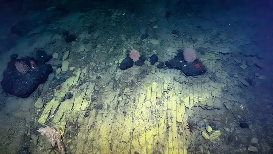
A Familiar Pattern More Than a Kilometer Below the Pacific
At the summit of Nootka Seamount, north of Hawaiʻi, a camera revealed something unexpectedly familiar in 2022: yellow rock divided into shapes resembling a neatly paved brick road. The formation lay more than a kilometer beneath the Pacific Ocean, inside Papahānaumokuākea Marine National Monument, where only about 3 percent of the seafloor has been visually surveyed.
Contents
- A Familiar Pattern More Than a Kilometer Below the Pacific
- How Lava Became a Pattern of Bricks
- Volcanic Rock Also Provides a Home for Life
- A Vast Protected Area Around the Northwestern Hawaiian Islands
- What the 2022 Expedition Collected
- Other Finds Along the Ancient Ridge
- A Timeline From Protection to a Global Exploration Study
- Less Than 0.001 Percent of the Deep Seafloor Has Been Seen
- Why the Deep Ocean Matters Beyond the Seabed
- Hawaiian Culture Was Part of the Mission
- Live Video Turned a Dive Into a Shared Discovery
- New Tools Can Expand the View
- The Bottom Line
Scientists aboard the exploration vessel Nautilus watched as a remotely operated vehicle moved across what looked like a dried lakebed. Viewers around the world followed the encounter through a live online broadcast. The team jokingly invoked The Wizard of Oz and the mythical city of Atlantis as the camera passed over the unusual surface.
The explanation was volcanic. According to the Ocean Exploration Trust, which operates Nautilus, the apparent paving is a fractured flow of hyaloclastite, a rock formed when hot lava meets cold seawater during energetic eruptions. Rock fragments settle on the seabed, and stresses associated with heating and cooling can later split the material into angular pieces.
At Nootka, sharp cracks meeting at roughly ninety degrees produced a mosaic resembling carefully arranged bricks. Physics and time, operating over millions of years, created the pattern. Its familiar appearance made an otherwise unfamiliar environment easier for people to picture, helping a scientific encounter reach audiences far beyond the ship.
The discovery came during the Luʻuaeaahikiikekumu expedition, called Ancient Seamounts of Liliʻuokalani Ridge, from April 7 to May 1, 2022. Alongside the striking footage, the mission collected rocks, biological samples and mapping data that help explain how ancient underwater volcanoes formed and how marine life occupies their slopes.
How Lava Became a Pattern of Bricks
The Ocean Exploration Trust described the formation as a fractured flow of hyaloclastite. The name refers to volcanic material produced when lava encounters water and breaks into fragments. During eruptions with substantial energy, those fragments can accumulate on the seabed, creating deposits that later record further changes in temperature and stress.
The team identified repeated heating and cooling during multiple eruptions as the likely explanation for the ninety degree fractures at this baked margin of the seamount. As rock changes temperature, different parts can expand or contract, placing stress on the material until cracks form.
A simple comparison is the cracked surface of a brownie: a solid surface can develop fractures as it responds to heat and cooling. The volcanic formation underwent its changes over a much longer period, producing the angular shapes seen by the vehicle's cameras.
Mineral deposits account for the yellow appearance of the rock, which looked particularly vivid under the powerful lights of the remotely operated vehicle, or ROV. Those lights allowed viewers to see a surface far below the ocean's sunlit waters.
The Ocean Exploration Trust, the organization operating the expedition, explained the scene in its official description:
What may look like a 'yellow brick road' to the mythical city of Atlantis is really an example of ancient active volcanic geology,
Similar natural patterns occur on land, including at the Giant's Causeway in Northern Ireland. Finding such an orderly looking surface at this depth made the Nootka encounter especially arresting. The exact sequence and timing of the eruptions that produced this particular pattern were not given.
Volcanic Rock Also Provides a Home for Life
Nootka's fractured rock has scientific value beyond its appearance. Hyaloclastite deposits can help researchers understand volcanic behavior, the formation of the seabed and the physical conditions that shape underwater ecosystems. Their structure preserves clues about the processes that built and changed the seamount.
Marine organisms also use volcanic surfaces as places to attach, shelter or feed. During the expedition, the team observed creatures living along and around the formation, including crinoids, commonly called sea lilies, that had occupied the unusual roadway.
These observations connect geology with biology. A rocky slope provides the physical setting for a community, while its cracks and exposed surfaces offer different places for organisms to live. Documenting both the rock and its inhabitants helps researchers understand how life colonizes environments that can appear inhospitable to people watching from above.
The wider expedition examined deep sea corals, sponges and microbes as well as volcanic material. Bringing those observations together allows researchers to study how the history of an underwater mountain relates to the life now found on it.
A Vast Protected Area Around the Northwestern Hawaiian Islands
Papahānaumokuākea Marine National Monument covers about 582,578 square miles of the Pacific Ocean. It is larger than all United States national parks combined and ranks among the world's largest marine conservation areas. Texas would fit within its boundaries, a comparison that helps convey the scale of the protected waters.
The monument was established in 2006 and expanded in 2016. It encompasses ten separate marine conservation areas around the Northwestern Hawaiian Islands, including coral reefs, deep sea habitats and sites of cultural importance to Native Hawaiian communities.
Only about 3 percent of this vast seafloor has been visually surveyed. Protection covers a huge area, but direct observations of its underwater landscapes and communities remain limited. The Nootka footage is one small view into that much larger environment.
Randy Kosaki, NOAA's deputy superintendent for research at Papahānaumokuākea Marine National Monument, described the gap in knowledge with a comparison to space exploration:
We literally have better maps of the moon than of the ocean floor,
Kosaki's comparison captures why mapping and camera surveys matter even within an established protected area. Researchers need information about the location of ridges, rocky slopes and living communities to understand what the monument contains and guide decisions about its care.
What the 2022 Expedition Collected
Luʻuaeaahikiikekumu explored the relatively uncharted waters of Liliʻuokalani Ridge, a chain of underwater volcanoes extending across the central Pacific. The ridge formed through ancient tectonic movements and activity along ridges in the ocean. The mission sought evidence that could help explain the origins of those old volcanic mountains.
Nautilus completed 11 ROV dives at depths of roughly 700 to 3,500 meters. The team collected nearly 600 pounds of rock, along with many biological samples, providing physical material for research beyond what could be learned from video alone.
The ship's multibeam mapping system surveyed 28,559 square kilometers, or 11,027 square miles, of seafloor. Multibeam equipment uses sound to measure seabed depths across a broad strip beneath a vessel, building a picture of the underwater terrain.
Of that total, 23,456 square kilometers, or 9,056 square miles, lay within the United States Exclusive Economic Zone. This is the maritime area where the country has rights over marine resources. Those figures mean about 82 percent of the area mapped during the expedition was within that zone.
The expedition's mapped area exceeded 28,000 square kilometers, while its dives offered much closer views of selected locations. Together, the maps, camera observations and samples help researchers investigate the geological structure of the region and the conditions in which corals, sponges and microbes live.
Other Finds Along the Ancient Ridge
Basalt rocks coated with ferromanganese crusts were among the expedition's other observations. Ferromanganese refers to material containing iron and manganese. The team encountered these coated rocks across different depths and levels of oxygen saturation, meaning different amounts of dissolved oxygen relative to what the water could hold.
Researchers also collected samples of manganese oxide crusts and found a pumice rock with an appearance resembling a sponge. These varied materials broadened the geological record gathered during the mission beyond the fractured yellow formation.
A swimming sea cucumber known as the headless chicken monster provided another memorable sight. Its translucent, ghostly appearance was captured on video, adding a very different kind of discovery to the expedition's observations of rocks and attached marine life.
Nootka Seamount itself is believed to be more than 50 million years old. It contains materials that could attract interest from deep sea mining, giving the documentation of its geology and living communities a practical conservation purpose as well as scientific value.
A Timeline From Protection to a Global Exploration Study
The yellow formation belongs to a story extending beyond a single dive. The monument's creation, the expedition and a later assessment of global exploration show how a protected place can still contain large gaps in scientific knowledge.
- 2006: Papahānaumokuākea Marine National Monument was established around the Northwestern Hawaiian Islands.
- 2016: The monument was expanded, bringing its area to about 582,578 square miles.
- April 7 to May 1, 2022: The Luʻuaeaahikiikekumu expedition explored the ancient seamounts of Liliʻuokalani Ridge and encountered the yellow formation at Nootka.
- 2025: Researchers from the Ocean Discovery League, Scripps Institution of Oceanography and Boston University published an analysis of how little of the deep seafloor had been visually observed.
By January 25, 2026, the 2022 footage remained a vivid example of what close observation can reveal. The later global study supplied a much wider measure of the work still needed to see the deep seabed.
Less Than 0.001 Percent of the Deep Seafloor Has Been Seen
The 2025 analysis assembled records from more than 43,000 deep sea dives conducted since the late 1950s. Led by researchers from the Ocean Discovery League, Scripps Institution of Oceanography and Boston University, it examined direct visual exploration of an enormous part of Earth.
The study defined the deep ocean as waters at least 200 meters deep. That environment covers about 66 percent of the planet, yet cameras have visually observed less than 0.001 percent of its seafloor.
The area seen is roughly comparable to Rhode Island, or about one tenth of Belgium. Those comparisons turn an extremely small percentage into something easier to imagine: decades of dives have provided direct images of an area similar to a small territory within a vast global environment.
Mapping and visual observation answer different questions. Sound based mapping shows the shape of the seabed, while photographs and video reveal the rocks and organisms at particular locations. Nautilus used both approaches, mapping broad areas and sending vehicles down for detailed inspection.
The study also found that only about 19 percent of dives had taken place on the high seas, which cover 58 percent of the ocean's surface. The high seas are waters beyond national jurisdiction. The figures show that exploration has been concentrated elsewhere, leaving large expanses with relatively few direct visits.
The Ocean Discovery League is working to make ocean research more widely accessible. The distribution of recorded dives gives that effort a concrete purpose: more places need the ability to investigate deep waters, and more parts of the ocean need direct observation.
Why the Deep Ocean Matters Beyond the Seabed
The Science Advances study connects the exploration gap with the deep ocean's role in climate and life. Deep waters help regulate the climate by absorbing most of the excess heat and a substantial share of the carbon dioxide produced by human activities.
Carbon dioxide is a gas that contributes to warming when it builds up in the atmosphere. Ocean absorption links remote underwater environments with changes experienced on land, making the deep sea relevant far beyond the vessels that explore it.
Marine biodiversity extends from microbial communities within mineral crusts to corals, fish and invertebrates that have not yet been named. Scientists estimate that millions of species remain undiscovered in the deep ocean. Some could contain biochemical information useful for developing medicines or understanding how life evolved on Earth.
Climate related changes, pollution and interest in seabed mining are increasing pressure on these environments. Baseline information, a record of conditions before further change, helps decision makers understand what exists and what human activity could affect.
The Nootka expedition contributed to that record through its samples, images and maps. Every documented coral or sponge community and every mapped ridge provides information that managers can use when deciding where activities should be restricted or allowed with caution.
Hawaiian Culture Was Part of the Mission
Luʻuaeaahikiikekumu incorporated Hawaiian cultural practices alongside its scientific work. A community cultural liaison led the inclusion of Hawaiian protocol throughout the expedition, and the mission's name carries significance connected with Hawaiian traditions and values associated with ocean exploration.
The team included science communication fellows, interns working in science and engineering, and a guest educator from Papahānaumokuākea Marine National Monument. Their participation connected the research vessel with learners and communities beyond the scientists conducting the dives.
Cross sections of geological samples collected during the mission were planned for display at the monument's Mokupāpapa Discovery Center in Hilo, Hawaiʻi. The center was using Hawaiian language materials developed to expand formal education about deep sea science.
The combination of scientific research and Indigenous knowledge gave the mission a connection to the communities for whom these waters carry cultural importance. Bringing local and Indigenous voices into exploration also helps connect decisions about marine protection with the people whose traditions are tied to the region.
Live Video Turned a Dive Into a Shared Discovery
Nautilus streamed video in 4K resolution, allowing anyone with an internet connection to follow the expedition. The broadcasts carried scientific observations beyond the ship, while moments such as the yellow formation made a remote environment recognizable to a broad audience.
The team hosted a record 114 live interactions between the ship and people ashore, reaching about 3,450 learners around the world. Conversations took place in Hawaiian, English and American Sign Language, widening participation in the expedition's educational work.
More than 70 media stories about the mission appeared online, on radio and on broadcast television through international outlets. Live expedition video received 582,000 views, while produced highlights attracted more than 2.9 million views.
The yellow formation's appeal was closely tied to its recognizable shape. An angular sheet of volcanic rock gave people something concrete to remember, while the wider expedition showed that the same seabed contains geological records and communities of living organisms.
Public access to such encounters can build support for marine conservation and interest in scientific careers. The broadcasts also brought the practical work of exploration into view: mapping terrain, choosing places to inspect, collecting samples and connecting observations with questions about volcanic history and marine habitats.
New Tools Can Expand the View
Advanced ROVs can remain underwater for longer periods, collect more sophisticated samples and produce images with greater resolution. Autonomous underwater vehicles, which operate without a pilot continuously directing their movements, can map larger areas more efficiently.
Environmental DNA analysis offers another way to detect marine life. Researchers can examine genetic material in environmental samples to identify the presence of species without seeing the organisms directly. This adds a different kind of evidence to cameras, maps and collected specimens.
International collaboration and wider access to research technology can help extend exploration into places with few recorded dives. The contrast between the high seas' 58 percent share of the ocean's surface and their 19 percent share of dives gives those efforts a measurable focus.
Nootka's yellow formation brought attention to one small patch of ancient volcanic rock. The expedition that found it produced a much broader body of information: 11 dives, nearly 600 pounds of rock, biological samples and 28,559 square kilometers of mapping. Its lasting value lies in combining a memorable discovery with evidence that helps researchers understand and protect the surrounding ocean.
The Bottom Line
- The yellow brick road at Nootka Seamount is fractured hyaloclastite, a volcanic rock formed when hot lava encounters seawater.
- The Ocean Exploration Trust identified heating and cooling during multiple eruptions as the likely cause of its ninety degree cracks.
- The formation was encountered during the April 7 to May 1, 2022 Luʻuaeaahikiikekumu expedition in Papahānaumokuākea Marine National Monument.
- The monument covers about 582,578 square miles, with less than 3 percent of its seafloor visually explored.
- Nautilus completed 11 dives, collected nearly 600 pounds of rock and mapped 28,559 square kilometers of seabed.
- A 2025 study of more than 43,000 dives found that less than 0.001 percent of the deep seafloor had been visually observed.
- The mission combined geological and biological research with Hawaiian cultural practices, multilingual education and broadcasts reaching audiences worldwide.