A rapid Pacific warming brings risks beyond winter
China's National Climate Center and National Marine Environmental Forecasting Center announced on October 9, 2026, that a super El Niño had formed in September, after just five months of rapid warming. The climate center measured a September sea surface temperature index of 2.94°C above normal, while the July to September average reached 2.54°C, crossing China's 2.5°C threshold for a super event.
Contents
- A rapid Pacific warming brings risks beyond winter
- What the measurements actually show
- How strong could the peak become?
- From May warming to a possible December peak
- A warmer winter can still bring dangerous cold
- Why 2027 is a major concern for China
- Historical losses show exposure, not a forecast bill
- Children face the largest disruption where services are fragile
- Food, power and storms connect the regional risks
- Warming raises the stakes, but attribution has limits
- Key Points
The centers expect further warming through late autumn or early winter. Zhao Junhu, chief forecaster at the National Climate Center, said the event could become the strongest since systematic monitoring began. That remains a forecast for its eventual peak, rather than a settled conclusion across every international dataset.
The immediate outlook includes a generally warmer Chinese winter, interrupted by potentially strong cold waves. The more serious warning concerns 2027: heightened flood risk in the Yangtze River basin, possible damage to northern grain production, and stronger, more widespread summer heat.
The threat extends far beyond China. UNICEF estimates that more than 347 million children in nearly 100 countries and territories could encounter unusually wet or dry conditions between October and December 2026. In Papua New Guinea, an estimated 1.2 million people already need direct food relief, with the largest agricultural effects expected from November.
These are different stages of the same developing event. Ocean temperatures can peak months before some of the most damaging consequences appear on land. The distinction matters for governments deciding whether preparation should concentrate on this winter or extend through the next growing season.
What the measurements actually show
El Niño involves unusually warm surface water across the central and eastern equatorial Pacific, coupled with changes in the atmosphere above it. The temperature indices describe departures from a normal reference temperature, not the actual temperature of the seawater.
China's climate center identifies an event when the three month running average of its monitoring index reaches at least 0.5°C above normal and meets the required persistence of at least five months. Its national intensity standard classifies a peak from 0.5°C to below 1.3°C as weak, from 1.3°C to below 2.0°C as moderate, and at least 2.0°C as strong. The super category begins at 2.5°C.
The July to September average of 2.54°C exceeded that final threshold by 0.04°C. The September monthly reading of 2.94°C was 0.35°C higher than August. Keeping the monthly value separate from the seasonal average prevents a short burst of ocean warming from being mistaken for a sustained event of the same intensity.
The marine forecasting center gave a different September figure: 2.84°C for Niño 3.4, a widely used monitoring region in the central and eastern Pacific. It recorded 3.64°C in Niño 3, farther east. The National Climate Center's 2.94°C monitoring index and the marine center's 2.84°C Niño 3.4 reading should therefore not be presented as identical measurements. The announcements do not explain the full methodological reason for the difference.
Both centers describe an eastern Pacific event, meaning that its strongest warm anomaly lies toward the eastern part of the equatorial ocean. The climate center found that the eastern warm water center was more than 3.0°C above normal in September. That geographic pattern helps explain why a single headline temperature cannot describe the entire event.
How strong could the peak become?
Zhao said this event reached super strength in five months, compared with seven to 15 months for the three previous super events. He put its possible peak at 3.2°C to 3.5°C, against previous peaks of up to 2.8°C. The marine center separately expects Niño 3.4 to approach 3.5°C and Niño 3 to exceed 4.0°C.
Reports describing World Meteorological Organization forecasts give an October to December Niño 3.4 average of approximately 3.7°C, compared with a previous seasonal record of 2.6°C in November 2015 to January 2016. Another account of a NOAA forecast gives a seasonal estimate of 2.7°C, possibly above 3.0°C, and cites a previous rolling average record of 2.4°C in 1982 to 1983.
Those figures differ, and cannot all be treated as forecasts from one interchangeable series. They involve different agencies, indices, reference periods or forecast products, with insufficient detail to reconcile every difference. China's previous super events are listed as 1982 to 1983, 1997 to 1998 and either 2014 to 2016 or 2015 to 2016, depending on the account.
A separate account of NOAA's Climate Prediction Center gives an 83% chance of a historic event during October to December. It also says NOAA's Relative Oceanic Niño Index, or RONI, had not reached record levels through August. RONI adjusts for warming in the surrounding tropical ocean, helping distinguish the El Niño signal from broader ocean heat.
Other reported NOAA probabilities concern an extremely strong event continuing through December and February, rather than specifically breaking a record. These are different forecast questions. Daily temperature peaks, including a reported anomaly of 3.4°C, also cannot establish a record in a dataset averaged over three months.
From May warming to a possible December peak
China's announcement follows August warnings of intensification, when the event had not yet met the sustained super threshold. The key change is that September monitoring now supports a formal classification, while forecasts still determine how much stronger it may become.
The sequence separates the arrival of warm conditions from the later confirmation of a persistent event:
- May 2026: China's centers identify El Niño conditions in the central and eastern equatorial Pacific.
- June 2026: The WMO confirms conditions are underway. Papua New Guinea declares the event and begins organizing its response.
- July to September: China's monitoring index averages 2.54°C, above the super threshold.
- October 9: China's centers announce that a super event formed in September.
- Late autumn or early winter: Chinese forecasts place the likely peak in this period; WMO forecasts described in reports point to December.
- February 2027: The WMO outlook gives a near 100% likelihood that El Niño will persist through this month.
- Spring and summer 2027: The event is expected to weaken or end, while effects on Chinese heat and rainfall may remain pronounced.
Earlier forecasts gave an 80% chance of formation before September and 90% before November. Those were advance probabilities, not a competing diagnosis of conditions after September. There is still uncertainty about the exact peak, the speed of decline and the timing of regional weather effects.
A warmer winter can still bring dangerous cold
National Climate Center director Chao Qingchen expects temperatures and precipitation across China to be generally above normal from December 2026 through February 2027. Cold waves may nevertheless occur slightly more often, with large swings between warm and cold conditions.
A seasonal average combines many days. Several unusually warm weeks can produce a warmer winter even when brief periods bring severe cold, snow or freezing rain. The center has specifically warned about strong cold waves and low temperature rain, snow and icing in southern China.
The autumn rainfall forecast is also uneven. For October and November, most of central and eastern China is expected to receive more rain than normal. Much of Jiangnan and some eastern parts of Southwest China could receive 50% to 80% more precipitation, increasing the risk of extreme rain, mountain floods, landslides and debris flows.
Southwestern Inner Mongolia and northeastern parts of Northwest China face the opposite outlook, with rainfall deficits of roughly 20% to 50%. That brings concerns about drought and forest or grassland fires. A wetter national season would not remove those local shortages.
The climate center also links much of the summer's unusual weather to the rapid development of El Niño, including two broad rain belts in eastern China and active, strong typhoons with prolonged wind and rainfall effects. Zhao cautions that El Niño changes atmospheric circulation and the likelihood of extremes; it does not directly explain every individual storm.
Why 2027 is a major concern for China
Chao said the effects of a typical strong El Niño can continue across seasons and often become most pronounced the following year. Even as Pacific temperatures fall in spring and summer 2027, China may experience more extreme weather, higher temperatures and stronger heat waves across a wider area.
The original October outlook identifies a relatively high risk of serious flooding in the Yangtze River basin in 2027. Senior National Climate Center engineer Li Xiang also warns that Northeast and North China, both major grain producing regions, should prepare for excessive rainfall and flooding during spring and summer.
Much of Northwest China and Xinjiang face a different agricultural concern: heat and insufficient rain. These regional differences mean that flood preparation in one grain producing area cannot substitute for drought planning elsewhere.
Xu Xiaofeng, president of the China Meteorological Service Association and a former deputy head of the China Meteorological Administration, warns about abrupt transitions from drought to flooding. An area struggling with water shortages can suddenly receive heavy rain or typhoon rainfall, creating risks that a seasonal precipitation average conceals.
Xu also points to mountainous parts of northwestern China, where rainfall that might be manageable elsewhere can cause serious damage because terrain, buildings and infrastructure have limited capacity to withstand it. Qinghai's meteorological bureau had earlier advised households to keep emergency supplies in anticipation of sudden weather changes on the plateau.
These are risk outlooks, not predictions of a specific flood date or location. Chao notes that sea temperatures, polar ice, land snow cover and natural variations within atmospheric circulation all affect China's climate. El Niño is one major influence among several.
Historical losses show exposure, not a forecast bill
The marine forecasting center points to China's disaster statistics in 1998 and 2016, associated with the later stages of two previous super El Niño episodes. Figures attributed to the National Bureau of Statistics, the Ministry of Civil Affairs and the national disaster reduction authorities put direct economic losses at 300.74 billion yuan in 1998 and 503.29 billion yuan in 2016.
The same historical totals record 5,511 deaths and missing people in 1998 and 1,706 in 2016. The numbers of people affected were approximately 350 million and 190 million, respectively. The 2016 monetary loss was about 67% higher than the 1998 total, while recorded deaths and missing people were fewer.
These figures cover natural disasters during the respective years. They are not a calculation of losses caused solely by El Niño, and the monetary comparison is not adjusted for inflation or changes in the value of exposed buildings, infrastructure and other assets.
Reports also put the worldwide toll associated with the 1997 to 1998 episode at at least 20,000 deaths and more than $34 billion in economic losses. These historical figures illustrate the scale of past exposure, but do not establish what China or the world will lose in 2027.
Children face the largest disruption where services are fragile
The UN News assessment describes UNICEF's estimate that more than 347 million children could face unusually wet or dry conditions from October through December. Approximately 190 million are in Asia and the Pacific, roughly 55% of the identified global total.
UNICEF Executive Director Catherine Russell describes how weather disruption reaches children through food, water, health care and housing:
For children, El Niño is far more than a weather pattern. It can mean increased displacement, malnutrition, water shortages and disease outbreaks.
Russell also warns of school closures and added financial hardship for families. The exposure estimate does not mean every child counted will suffer a disaster. It identifies a very large population living where unusual rainfall or dryness could disrupt essential services.
UNICEF says 1.1 billion children, nearly half of all children globally, already face at least three overlapping climate hazards. Across the Greater Horn of Africa, wetter conditions could bring river floods, flash floods and waterborne disease. Children affected by conflict and displacement in Yemen, Sudan and Afghanistan face added risks where food and basic services are already difficult to obtain.
Papua New Guinea shows how an anticipated event can become an immediate emergency. Its government has established a task force and approved a $112 million supplementary budget. Water shortages, crop losses, depleted food reserves and rising prices are already reported, alongside disrupted schooling and concerns about nutrition and bushfires.
Food, power and storms connect the regional risks
UN Economic and Social Commission for Asia and the Pacific analysis found that more than 70% of Southeast Asia's land area experienced drought during the 2015 to 2016 event. More than 200 million people were exposed to severe drought at its peak, illustrating how rainfall disruption can spread across countries.
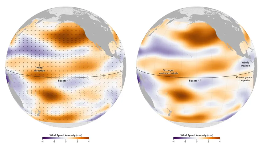
Justin Sentian, a climate change professor at Universiti Malaysia Sabah, explains that weaker Pacific trade winds shift warm water and rainfall eastward, depriving parts of Southeast Asia of moisture. Agriculture, hydropower, water supplies and electricity demand can come under pressure together. Remote communities dependent on shallow wells and streams may have fewer alternatives than cities with centralized utilities.
India's earlier concerns centered on a potentially weaker or delayed monsoon, crop planting and urban water supplies. Devender Sharma, an agricultural expert and activist, warned that extreme heat and El Niño could combine to damage agriculture. These were advance warnings, not confirmation of how much rain the eventual monsoon delivered.
Food disruption can also cross oceans. The IHE Delft Institute for Water Education warns that drought in producing countries can threaten staple imports to Europe. Its examples include maize and beans in Nicaragua, and constraints on irrigated crops in Colombia, northeastern Brazil and India.
The reported hurricane pattern is another contrast: nine named Atlantic storms and one hurricane, against 16 eastern and central Pacific storms, including four major hurricanes. The Atlantic's first hurricane, Isaias, formed late on October 7. Strong El Niño commonly produces atmospheric conditions less favorable for Atlantic hurricanes while supporting greater activity in the Pacific, although it is not the only influence on either basin.
Warming raises the stakes, but attribution has limits
El Niño releases heat stored in the ocean and rearranges where heat and rainfall occur. It does not create new planetary heat. WMO Secretary General Celeste Saulo, speaking about the ocean supplying this event, said:
The ocean it's drawing from is the warmest we've ever measured it. There is simply more heat available to release.
Francisco Estrada, coordinator of the Climate Change Research Program at the National Autonomous University of Mexico, argues that El Niño and global warming must be assessed together. A warmer background climate can make the same ocean anomaly more damaging through heat, evaporation and heavier rainfall.
Research accounts differ on how confidently warming can be linked to greater El Niño strength. One cites an estimate of events becoming 36% stronger than before the industrial era. Another describes ancient coral evidence of increasing intensity but says the study did not attribute that change to climate change. Models also have difficulty reproducing temperature trends in the eastern tropical Pacific. Neither finding establishes how much of this particular event's strength is caused by human activity.
Preparation therefore need not wait for a final attribution result. Xu calls for forecasts that are updated as conditions develop, stronger warnings and protection targeted at vulnerable infrastructure. World Food Programme regional director Samir Wanmali urges social protection systems that can expand during crises. Reports also describe 59 adaptation indicators adopted at COP30, covering areas such as water, agriculture and warning systems. Their adoption does not demonstrate that any country is ready for this event.
A regional El Niño exchange in Bangkok is due to begin the week after the UN assessment, bringing governments, meteorological experts and UN agencies together. The next decisive information will come from updated ocean monitoring and regional seasonal forecasts. The exact peak, final record ranking and locations of the worst 2027 impacts are not yet settled.
Key Points
- China announced that a super El Niño formed in September 2026 after rapid warming beginning in May.
- The National Climate Center's July to September index averaged 2.54°C above normal, crossing its 2.5°C super threshold.
- A peak is expected in late autumn or early winter, but record claims vary with the dataset and averaging method.
- China expects a generally warmer winter, with strong cold waves and sharp temperature swings still possible.
- Flooding, agricultural disruption and stronger heat waves are major concerns for spring and summer 2027.
- UNICEF estimates more than 347 million children could face unusually wet or dry conditions in October to December.
- Papua New Guinea already faces food and water shortages, with approximately 1.2 million people needing direct food relief.